| Upper Hungary
http://en.wikipedia.org/wiki/Upper_Hungary |
Upper Hungary (Hungarian:
Felső-Magyarorsz�g or
Felvid�k, Slovak:
Horn� Uhorsko) is
the usual English translation for the area that was historically
the northern part of the Kingdom
of Hungary, now mostly present-day Slovakia.[2][3][4][5]
The population of Upper Hungary was mixed and mainly consisted
of Slovaks,
Hungarians,
Germans
and Ruthenians.
In fact the first complex demographic data are from the 18th
century. In the 18th - 20th centuries Slovaks were majority
population of Upper Hungary.[6]
Slovaks called this territory "Slovensko"
(Slovakia), which term appears in written documents from the
15th century, but it was not precisely defined and the region
inhabited by Slovaks held no distinct legal, constitutional, or
political status within Upper Hungary.[7]
The Upper Hungary included the counties of Posoniensis,
Nitriensis,
Barsiensis,
Honthum,
Trentsiniensis,
Thurociensis,
Arvensis,
Liptovium,
Zoliensis,
Geomoriensis
et Kishonthensis, Scepusium,
Abaujvariensis
et Tornensis, Sarossiensis
and Zemplinum.[6]
In the last and also controversial
census 1910 in the Kingom of Hungary, the Slovak language
users were majority in the mostly of these counties.[8]
Etymology
Historical
usage
Historically there are different meanings:
1. The older Hungarian
term Felső-Magyarorsz�g (literally: "Upper
Hungary"; Slovak:
Horn� Uhorsko; German:
Oberungarn) formally
referred to what is today Slovakia
in the 16th-18th centuries and informally to all the northern
parts of the Kingdom
of Hungary in the 19th century.
2. There are some 16th century sources which refer to the
Slovak inhabited territory of the Kingdom of Hungary as "Sclavonia"
or "Slov�ky", names that distinguish the region
ethnically as well as geographically.[9]
3. The Hungarian
Felvid�k (literally: "Upper Country",
"Upland", "Highland"; Slovak:
Horn� zem; German:
Oberland; Yiddish:
אױבערלאַנד)
has had several informal meanings:
- In the 19th century and part of the 18th, it was usually
used:
- to denote the mountainous northern part of the Kingdom
of Hungary as opposed to the southern lowlands
- more generally, to denote regions or territories
situated at a higher altitude than the settlement of the
speaker
- as a synonym for the then-meaning of Felső-Magyarorsz�g
Modern
usage
After World War I, the meaning of Felvid�k in the
Hungarian language (Felső-Magyarorsz�g was not used
anymore) was restricted to Slovakia
and Carpathian
Ruthenia. Today the term Felvid�k is sometimes used
in Hungary when speaking about Slovakia, and it is exclusively
(and anachronistically) used in Hungarian historical literature
when speaking about the Middle Ages, i.e., before the name
actually came into existence. The three counties of the region
that remained in Hungary after World War I, however, are never
called Upper Hungary today, only Northern
Hungary (�szak-Magyarorsz�g). Any use of the word Felvid�k
to denote all of modern Slovakia is considered offensive by
Slovaks,[12]
and inappropriate by some Hungarians,[13]
but it is now commonly used by the sizeable Hungarian minority
in the southern border-zone of Slovakia[14]
to identify the Hungarian-majority areas where they live.[15]
Some of them call themselves felvid�ki magyarok, i.e.
the "Upland Hungarians." The word felvid�k
also functions as an ordinary noun used to denote areas at
higher elevations in present-day Hungary.[16]
History
of Upper Hungary
Middle
Ages
The term Upper Hungary often occurs in publications on
history as a somewhat anachronistic translation of other,
earlier (at that time Latin)
designations denoting approximately the same territory. These
other terms were, for example, Partes Danubii
septentrionales (Territories to the north of the Danube)
or Partes regni
superiores (Upper parts of the Kingdom).
The actual name "Upper Hungary" arose later from the
latter phrase. In the 15th century, the "Somorja,
Nagyszombat,
Galg�c,
Nyitra,
L�va,
Losonc,
Rimaszombat,
Rozsny�,
J�sz�,
Kassa,
G�lsz�cs,
Nagymih�ly"
line was the northern "boundary" of the Hungarian
ethnic area.[17]
Affiliation
to Hungary
The Principality
of Nitra emerged in the 8th century and developed into an
independent Slavic state; although the polity may have lost its
independence when it was still at the stage of development.[18][19]
In the early 9th century, the polity was situated on the
north-western territories of present-day Slovakia.[20]
Toponyms may prove that the nomadic Magyars occupied the Western
Pannonian Plain in the Upper Hungary, while the hills were
inhabited by a mixed (Slav and Hungarian) population and people
living in the valleys of the mountains spoke Slavic
language.[21]
16th
- 18th centuries
The term emerged approximately after the conquest of today's
Hungary by the Ottomans
in the 16th century when Felső-Magyarorsz�g
(German: Oberungarn; Slovak: Horn� Uhorsko)
referred to present-day whole
Slovakia and the adjacent territories of today's Hungary
and Ukraine
that were not occupied by the Ottoman
Empire. That territory formed a separate military district
(the "Captaincy of Upper Hungary" (1564�1686)
headquartered in Kaschau/Kassa/Ko�ice)
within Royal
Hungary. At that time, present-day western
Slovakia, and sometimes also the remaining territories of
Royal Hungary to the south of it, were called Lower Hungary
(Hungarian: Als�-Magyarorsz�g; German: Niederungarn;
Slovak: Doln� Uhorsko).
It was briefly a separate vassal
state of the Ottoman
Empire under Imre
Th�k�ly in the 1680s.
This usage occurs in many texts up to around 1800 � for
example, the renowned mining school of Schemnitz/Selmecb�nya/Bansk�
�tiavnica in present-day central Slovakia was founded in
"Lower" Hungary (not in "Upper" Hungary) in
the 18th century and Pozsony (today Bratislava)
was also referred to as being in "Lower" Hungary in
the late 18th century.
17th
century - early 20th century
From the end of the 17th century (in many texts however only
after around 1800) until 1918, the territory of the Kingdom
of Hungary north of the Tisza
and the Danube,
which comprised present-day Slovakia,
Carpathian
Ruthenia, and approximately the Hungarian
counties of N�gr�d,
Heves,
and Borsod-Aba�j-Zempl�n,
was informally called either "Upper Hungary" or
"Upland" (Felső-Magyarorsz�g or Felvid�k).
Although not strictly defined, the name Felvid�k became
commonplace to the point that at least one publication
concerning the area used it as its title.[22]
Other nations used the terms "Upper Hungary" (for the
northern part of the Kingdom), "Slovakia" (only for
the territory predominantly inhabited by the Slovaks),
and "Ruthenia" (the territory predominantly inhabited
by the Ruthenians) in parallel. The Slovaks themselves called
the territories of the Kingdom of Hungary to the south of
Slovakia Doln� zem ("Lower Land").
In the course of the creation of Czechoslovakia
at the end of World War I, Czechoslovakia originally demanded
that all of the so-called Upper Hungary be added to Czechoslovak
territory (i.e. including the territory between the Tisza
River and present-day Slovakia).
The claim for its acquisition, however, was not based on the
whole area having a single common name, "Upper
Hungary", but on the presence of a Slovak minority in the
region.
Population
in the 18th century
In 1720 of the 63 largest town on the territory of
present-day Slovakia with at least 100 taxpaying households 40
had Slovak majority, 14 German and 9 Hungarian majority.[17]
Population
in the 19th century
The first ethnic data of whole Hungarian Kingdom by county
was published in 1842. According to this survey the total
population of the counties in Upper Hungary exceeded 2.4
million, with the following ethnic distribution: 59.5% Slovaks,
22% Magyars,
8.3% Ruthenians,
6.7% Germans
and 3.6% Jews.[17]
 |
 |
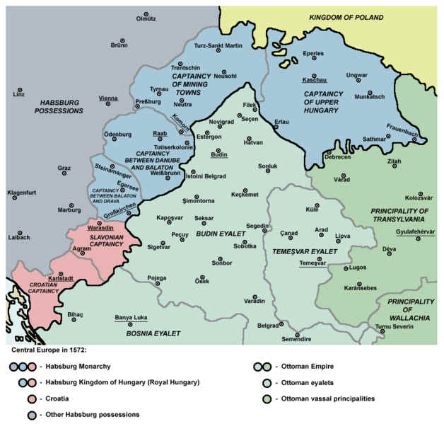
| Captaincy of Upper Hungary in 1572 |
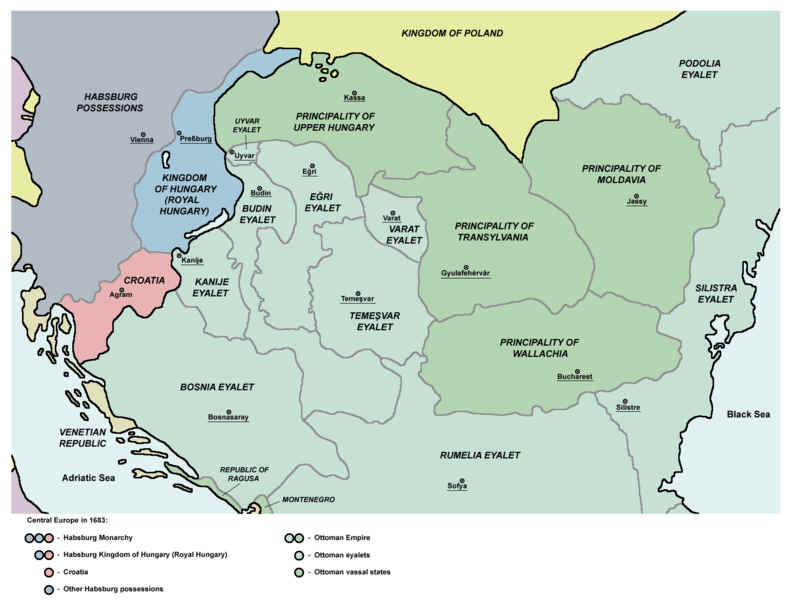
Principality of Upper Hungary in 1683 |
|