|
| |
|
Illinois
| http://en.wikipedia.org/wiki/History_of_Illinois |
History of Illinois
Pre-Columbian
era
Cahokia,
the urban center of the pre-Columbian Mississippian
culture, was located near present-day Collinsville,
Illinois. That civilization vanished circa 1400–1500 for
unknown reasons. The next major power in the region was the Illiniwek
Confederation, a political alliance among several tribes. The
Illiniwek gave Illinois its name. The Illini suffered in the
17th century as Iroquois
expansion (caused by European expansion in the eastern United
States) forced them to compete with several tribes for land. The
Illini were replaced in Illinois by the Potawatomi,
Miami,
Sauk,
and other tribes.
European
exploration and colonization
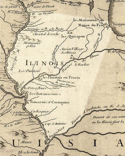
French explorers Jacques
Marquette and Louis
Jolliet explored the Mississippi
and Illinois
Rivers in 1673. As a result of their exploration, the Illinois
Country was part of the French
empire until 1763, when it passed to the British. The area
was ceded to the new United States in 1783 and became part of
the Northwest
Territory.
|
| http://en.wikipedia.org/wiki/History_of_Illinois |
American
Territory
The Illinois-Wabash
Company was an early claimant to much of Illinois. The Illinois
Territory was created on February 3, 1809. Illinois saw the
construction of numerous civilian forts during the War
of 1812, as well as the short-lived Fort
Johnson.
Statehood
On December 3, 1818, Illinois became the 21st U.S. state.
Early U.S. settlement began in the south part of the state and
quickly spread northward, driving out the native residents. In
1832, some Indians returned from Iowa but were driven out in the
Black
Hawk War, fought by militia.
Illinois is known as the "Land of Lincoln"
because it is here that the 16th President spent his formative
years. Chicago
gained prominence as a lake and canal port after 1848, and as a
rail hub soon afterward. By 1857, Chicago was the state's
dominant metropolis. |
| http://en.wikipedia.org/wiki/Illinois_Territory |
Illinois Territory
| The Territory of Illinois was an organized
incorporated territory of the United States that
existed from March 1, 1809, until December 3, 1818, when
the southern portion of the territory was admitted to
the Union
as the State
of Illinois. The area was earlier known as "Illinois
Country" while under French control, first as
part of French
Canada and then as part of Louisiana.
The British
gained authority over the region with the 1763 Treaty
of Paris, marking the end of the French
and Indian War. During the American
Revolutionary War, Colonel
George Rogers Clark took possession of the entire
Illinois Country for Virginia,
which established the "County
of Illinois" to exercise nominal governance
over the area. Virginia later ceded nearly all of its
claims to land north of the Ohio
River to the Federal
government of the United States in order to satisfy
objections of land-locked states. The area had been a
part of the larger Northwest
Territory (from 13 July 1787 until 4 July 1800), and
then part of the Indiana
Territory as Ohio
prepared to become a state. On 3 February 1809, the 10th
United States Congress passed legislation
establishing the Illinois Territory, after Congress
received petitions from residents in the far western
areas complaining of the difficulties of participating
in territorial affairs. |
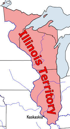 |
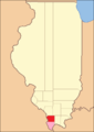
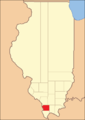
Boundaries
The Illinois Territory originally included lands that became
the states of Illinois, Wisconsin,
the eastern portion of Minnesota,
and the western portion of the upper peninsula of Michigan.
As Illinois was preparing to become a state, the remaining area
of the territory was attached to the Michigan
Territory.
The original boundaries of the Territory were defined as
follows: “...all that part of the Indiana Territory which lies
west of the Wabash river, and a direct line drawn from the said
Wabash river and Post Vincennes, due north to the territorial
line between the United States and Canada...”
Kaskaskia
was the territorial capital. The 1810 census showed a population
of 12,282.[1] |
| |
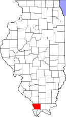
Kaskaskia, Illinois
Kaskaskia is a village in Randolph
County, Illinois,
United
States. In the 2010
census the population was 14, making it the second-smallest
incorporated community in the State of Illinois in terms of
population.[1]
A major French
colonial town of the Illinois
Country, its peak population was about 7,000 when it was a
regional center in the 18th century. Kaskaskia then became the
capital of the United States' Illinois
Territory, created on February 3, 1809. In 1818, when
Illinois became the 21st U.S. state, it briefly served as the
state's first capital until 1819, when the capitol moved to Vandalia.
Most of the town was destroyed in April 1881 by flooding, as
the Mississippi
River shifted eastward to a new channel, taking over the
lower 10 miles (16 km) of the Kaskaskia
River. This resulted from deforestation
of the river banks during the 19th century, due to the need for
wood fuel to feed the steamboat traffic. The river now passes
east rather than west of the town. The state boundary line,
however, remained in its original location. Accordingly, if the
Mississippi River is considered to be a break in physical
continuity, Kaskaskia is an exclave
of Illinois, lying west of the Mississippi and only reachable
from Missouri. A bridge crosses the old riverbed, a creek that
is sometimes filled with water, and sometimes not. Kaskaskia has
Missouri telephone area code and a Missouri zip code.
History
The town was named after the Native American word for the Kaskaskia
River. At first favorably situated on a peninsula, the town
was cut off and mostly destroyed by repeated flooding
and a channel change by the Mississippi River.
The site of Kaskaskia near the river was first a Native
American village, inhabited by varying indigenous peoples
for thousands of years.
In 1703 French
Jesuit
missionaries established a mission with the goal of converting
the Illini
Native
Americans to Catholicism.
The congregation built its first stone church in 1714. The
French also had a trading post in the fur
trade at the village.[3]
French settlers moved in to farm and to exploit the lead mines
on the Missouri
side of the river. Kaskaskia became the capital of Upper
Louisiana and the French built Fort
de Chartres in 1718. In
In 1733 the French built Fort
Kaskaskia near this site. It was destroyed by the British in
1763 during the French
and Indian War (also known as the Seven
Years War), which they won. Rather than live under British
rule after France ceded the territory east of the river, many
French-speaking people from Kaskaskia and other colonial towns
moved west of the Mississippi to Ste.
Genevieve and St.
Louis, and other areas.
The city fell on July 4, 1778 to George
Rogers Clark and his force of 200 men including Captain
Leonard Helm during one of the western most battles of the American
Revolution. The parish rang the church bell in celebration,
which has since been called the "liberty bell". It is
housed in a brick building shrine
near the Church of the Immaculate
Conception. The brick church was built in 1843 in the
squared-off French style.[7]
As a center of the regional economy, Kaskaskia served as the
capital of Illinois Territory from 1809 until statehood was
gained in 1818, and then as state capital until 1819. Its peak
population was about 7,000 before the capital moved in 1819 to Vandalia.
Although introduction of steamboats
on the Mississippi River stimulated the economies of river towns
in the 19th century, their use also had devastating
environmental effects. Deforestation
of the banks followed steamboat crews' regular cutting of trees
to feed the engine fires. River banks became unstable and
collapsed into the water.
|
| http://www.state.il.us/hpa/lib/ILChronology.htm#1778 |
Illinois Timeline
| 1778 |
George
Rogers Clark (1752-1818) defeats the British at Kaskaskia,
securing the Illinois country for Virginia. |
| 1779 |
Jean
Baptiste Point du Sable (1745?-1818) establishes a trading
post at present Chicago. |
| 1783 |
Treaty
of Paris extends the United States boundary to include the
Illinois country. |
| 1784 |
Virginia
relinquishes its claim to Illinois. |
| 1787 |
Northwest
Ordinance places Illinois in the Northwest Territory. |
| 1788 |
Arthur
St. Clair (1734-1818) becomes the first governor of the
Northwest Territory. |
| 1800 |
Congress
creates the Indiana Territory, which includes Illinois. |
| 1803 |
Kaskaskia
Indians cede nearly all of their Illinois lands to the
United States. |
|
United
States Army establishes Fort Dearborn at present Chicago. |
| 1804 |
William
Clark (1770-1838) and his troops depart from Camp Dubois,
Madison County, to join Meriwether Lewis (1774-1809) for
westward explorations. |
| 1809 |
Congress
organizes the Illinois Territory, with Kaskaskia the
capital, Ninian Edwards (1775-1833) the governor. |
| 1811 |
The
first coal mine in Illinois is opened in Jackson County. |
|
New
Madrid, Missouri, earthquake, the largest in United States
history, damages southern Illinois (recurs in 1812). |
| 1812 |
Potawatomi
Indians massacre fifty-two troops and civilians in
destroying Fort Dearborn. |
| 1813 |
Land
offices are opened at Kaskaskia and Shawneetown. |
| 1814 |
The
first newspaper in the state, the Illinois Herald,
is published at Kaskaskia. |
| 1816 |
Fort
Armstrong is built at Rock Island, and Fort Dearborn is
rebuilt at Chicago. |
|
The
first bank in Illinois, at Shawneetown, is chartered by
the territorial legislature. |
| 1817 |
Morris
Birkbeck (1764-1825) and George Flower (1780-1862)
establish an English settlement at Albion. |
|
War
of 1812 veterans begin receiving 160-acre land warrants in
the Illinois Military Tract, a region between the Illinois
and Mississippi rivers. |
| 1818 |
Illinois
becomes the twenty-first state, with Kaskaskia the capital
and Shadrach Bond (1773-1832) the first governor.
Population of the state is 34,620. |
| 1819 |
Kickapoo
Indians move west of the Mississippi, relinquishing most
claims to central Illinois lands. |
| 1820 |
Vandalia
becomes the state capital. |
| 1821 |
General
Assembly charters a state bank at Vandalia, with branches
at Shawneetown, Edwardsville, and Brownsville. |
| 1823 |
Galena
becomes a center for lead mining. |
| 1824 |
Voters
defeat a constitutional convention call to permit slavery
in the state. |
| 1825 |
Gurdon
S. Hubbard (1802-1886) establishes the Vincennes Trace
from southern Illinois to Lake Michigan. |
|
General
Assembly enacts the first public school law and levies a
school tax. |
|
Marquis
de Lafayette (1757-1834) visits Kaskaskia and Shawneetown
on a tour of the United States. |
| 1827 |
John
Mason Peck (1789-1858) founds Rock Spring Seminary, the
first college in the state. |
| 1829 |
Chippewa,
Ottawa, and Potawatomi cede lands in northern Illinois by
treaty at Prairie du Chien. |
| 1830 |
The
first state prison is built at Alton. |
|
Abraham
Lincoln (1809-1865) moves to Illinois from Indiana. |
|
James
Hall (1793-1858) launches Illinois Monthly Magazine,
the first literary periodical published west of Ohio. |
| 1832 |
Black
Hawk War ends with Sauk and Fox Indians leaving the
Illinois lands they had ceded in 1804. |
| 1833 |
Treaty
of Chicago provides for United States acquisition and
settlement of the last remaining Indian lands in Illinois. |
|
| http://genealogytrails.com/ill/johnson/towns/elvira.html |
Elvira
Johnson County, Illinois
A mile north and two miles west of the village of Buncombe
is a large spring of cold water. To this spring came a band
of pioneers in the year 1806. The band was made up of
families named Worley, Thornton, Bradshaw and Wiggs. Other
families accompanied them or came to settle here soon after,
for in 1809 John Bradshaw was appointed Justice of the Peace
there.
Illinois became a territory in 1809. Johnson County was
formed by the Illinois Territorial Legislature that year. It
included what is now Alexander, Pulaski, Massac, Johnson,
and parts of Pope, Saline, Hardin, Jackson and Williamson
Counties. The articles that created the county named
"Elvira Township" as "all the land within the
bounds of protection of Captain William Thornton's Company
of militia." This poorly defined area varied from 49 to
100 square miles.
The county was named for a Colonel of the Kentucky Militia,
whose name was Richard Menton Johnsosn. This Colonel became
the Vice President of the United States to be elected by the
Senate. He served one term under President Martin Van Buren,
but this term of office began 27 years after the new county
was named for him.
The community about the spring was named the County Seat. A
log courthouse was built there in 1809. This building served
for five years. William Simpson, a carpenter, built the
second courthouse in Elvira. This was a frame building made
of unplaned native lumber.
Whether Mr. Simpson furnished the lumber is not known. His
brother had a sawmill and a stave mill at Simpson. William
Simpson was to receive $260.00 for the building, in three
annual payments. He was paid only $175.75. This is slightly
over two installments. The reason for not paying the amount
in full is not known. The county Jail was built at a cost of
five hundred dollars.
Elvira got a post office February 23, 1815. The post office
was called The Johnson Court House. The name was changed to
Elvira in December of 1818. This post office was
discontinued but no record of it's closing exists. It was
re-established March 2, 1869 and continued until July 14,
1907.
The reason for the naming the community Elvira is not known.
It is a female Christian name and was supposedly named for
some woman dear to the heart of some official in the
Illinois Territory that early day. Some legend states that
Elvira was the name of Governor Shadric Bond's wife, and the
seat of Johnson County was named after her.
On December 3rd, 1818, the Illinois Territory became the
twenty-first state of the United States. The county seat was
moved to a new town; named Vienna, from a town in Austria.
The old village of Elvira gradually declined. Today a
careful examination of the newly ploughed ground there will
reveal a few pieces of building stone, brick, and pottery
and dishes, signifying that it was once a dwelling place.
This spring is in the middle of a field, walled with
sandstone and still flowing with cold water. A new community
sprang up a mile west of the old village and was called
Elvira. It consisted of a half dozen houses and a country
store.
From Ghost Towns Of
Southern Illinois by Glenn J. Sneed.
Reprinted in The Vienna
Times, April 12, 1973.
|
| |
|
| http://archive.org/details/historyofalexand00perr |
History
of Alexander, Union and Pulaski Counties, Illinois
History
of Alexander, Union and Pulaski Counties, Illinois
|
| http://www.findagrave.com/cgi-bin/fg.cgi?page=csr&CScnty=780&CSsr=21& |
Union County, Illinois Graveyards |
| http://landplats.ilsos.net/Union.html |
Union County, Illinois platmaps |
| http://en.wikipedia.org/wiki/Union_County,_Illinois |
Union County is a county
located in the U.S.
state of Illinois.
According to the 2010
census, it has a population of 17,808, which is a decrease
of 2.7% from 18,293 in 2000.[1]
Its county
seat is Jonesboro.[2]
History
Union County was formed out of Johnson
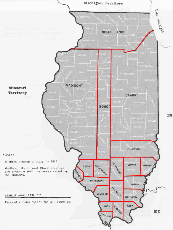
County in 1818, the same year Illinois joined the Union.
It was named for a joint revival meeting of the Baptists
and Dunkards,
called a "union meeting". The county seal depicts the
leaders of these two groups shaking hands.[4]
|

|
|
|
|
Official County Seal |
For its first year of existence, Union County included
an area of unorganized territory temporarily attached to
it.[5] |
In 1819, the additional territory became Alexander
County, reducing Union to its current borders. |
|
| http://genealogytrails.com/ill/union/1818census.html |
Census of 1818
Union County Illinois Genealogy
Trails
| Line # |
Name |
Males over 21 |
All others |
| 349 |
Thornton, John |
1 |
4 |
| 120 |
Thornton, William Jr |
1 |
2 |
|
| http://genealogytrails.com/ill/union/1820census.html |
The
1820 Census for Union County, Illinois
Union
County Illinois Genealogy Trails
| NAME |
FREE
WHITE MALES 21 AND OLDER |
ALL
OTHER WHITE INHABITANTS |
SERVANTS
OR SLAVES |
|
| |
|
| http://en.wikipedia.org/wiki/Johnson_County,_Illinois |
Johnson County, Illinois
go here for maps, hx etc |
| |
|
| http://genealogytrails.com/ill/ilstate.htm#prestatehood |
Illinois Genealogy Trails State Data Page
Forts of Illinois
|
Union County Forts
http://genealogytrails.com/ill/forts.html
|
CAMP ANNA
CAMP ANNA - A Civil War encampment,
this post was located at or near the town of
Anna in Union County.
CAMP DOUGLAS
CAMP DOUGLAS - An extensive Federal
Civil War encampment, first a camp for the
instruction of recruits, then a camp for
Confederate prisoners, Camp Douglas was
established in Chicago in 1861 and soon became
one of the two principal places for the
mustering of Illinois regiments (the other being
Camp Butler at Springfield). The 60-acre camp
was then located between 31st Street and College
Place, and Cottage Grove and Forest avenues. It
covered the land through which has since been
opened Calumet, South Park, Vernon, and Rhodes
avenues, between 31st and 33rd streets. The
camp's main gate was at what is now 32nd Street
and Cottage Grove Avenue. To the south of the
camp was the old university, to the west and
north was prairie land, clumps of trees, and
thinly scattered houses, which have all long
since given way to the march of progress.
Camp Douglas remained as a camp of instruction
until after the battle of Fort Donelson in
February 1862 when by official order it was
prepared for the reception of prisoners taken
from Island No. 10. Nearly 9,000 prisoners -
weak, worn-out, sick, and wretched - came to
Chicago in the first lot. In November of 1863 a
nearly successful attempt to escape was made. A
number of the prisoners removed the boards from
the floor of their barracks and digging down a
few feet ran a tunnel under the fence and one by
one silently crept through and out and fled into
the darkness. Some 70 or more of them had
escaped before the discovery of their plans, and
about 50 of them were afterward recaptured.
In 1864 Chicago figured dramatically in one of
the most daring plans devised by Confederate
leaders. The plan called for the Confederate
prisoners at Camp Douglas to break out of prison
on the eve of the presidential election. But an
informer, who while a prisoner had been privy to
the prisoners' grapevine, and who had since
escaped, related the details of the plot to the
commandant. Federal agents on the night before
the election, November 7, arrested some of the
conspirators at a fashionable Chicago hotel and
at the home of another near the camp where a
veritable arsenal of weapons was found.
At the opening of the year 1865, the camp held
17,880 prisoners. In February the release began
and continued irregularly until August 1865,
when all but about 200 who were too ill to be
moved had been discharged, and the office of
Camp Douglas as a prison camp was closed. The
barracks, fences, and improvements were torn
down. The sale of the government property began
on November 24, 1865, and continued until all
was sold.
CAMP DOUGLAS - A temporary Civil War
encampment "near Jonesboro Station" at
Anna in Union County.
CAMP DUBOIS
CAMP DUBOIS - On December 13, 1803,
the Lewis and Clark Expedition set up a winter
base camp where the Wood River emptied into the
Mississippi River. The site is on the Illinois
bank, some 23 miles upriver from St. Louis and
opposite the mouth of the Missouri River. The
camp, near the present towns of Wood River and
Hartford in Madison County, was established in
Illinois territory for several reasons,
principally because St. Louis was then
technically a French possession, although
actually governed by a Spanish commandant, and
because both the French and Spanish in St. Louis
were suspicious of American intentions. The camp
was named "Dubois" because its site
was located at La Rivière Dubois, as the local
French called the Wood River. On May 11, 1804,
seven voyageurs arrived from St. Louis, They had
been engaged to help paddle the exploration
party up the Missouri River as far as the second
winter encampment in North Dakota. On May 14 the
40 men in the party, led by Meriwether Lewis and
William Clark, abandoned their camp and set off
on their great adventure.
CAMP DUBOIS - A temporary Civil War camp
at or near Alton in Madison County.
CAMP DUBOIS - A temporary Civil War camp,
established in December 1861 at or near Anna in
Union County.
|
|
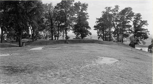
| http://genealogytrails.com/ill/fortpictures.html |
| Fort Kaskaskia Ruins |
 |
|
| http://genealogytrails.com/ill/hunting.html |
Prairies of Illinois
|
Union
|
Clark
|
SE
part of Co 5 miles long and 3 miles wide
|
|
Union
|
Schuyler
|
4
miles W of Rushville
|
PRAIRIES
- A peculiar feature of the country, in the middle
and northern portion of the State, which excited the
amazement of early explorers, was the vast extent of
the prairies or natural meadows..... In spite of the
uniformity in altitude of the State as a whole, many
sections present a variety of surface and a mingling
of plain and woodland of the most pleasing
character. This is especially the case in some of
the prairie districts where the undulating landscape
covered with rich herbage and brilliant flowers must
have presented to the first explorers a scene of
ravishing beauty, which has been enhanced rather
than diminished in recent times by the hand of
cultivation. Along some of the streams also,
especially on the upper Mississippi and Illinois,
and at some points on the Ohio, is found scenery of
a most picturesque variety. [Historical Encyclopedia
of Illinois", 1901]
|
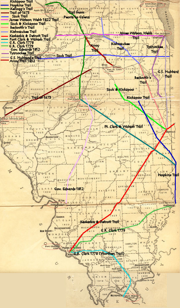
| http://genealogytrails.com/ill/trailsmap.html |
Early Illinois Territory Trails
|
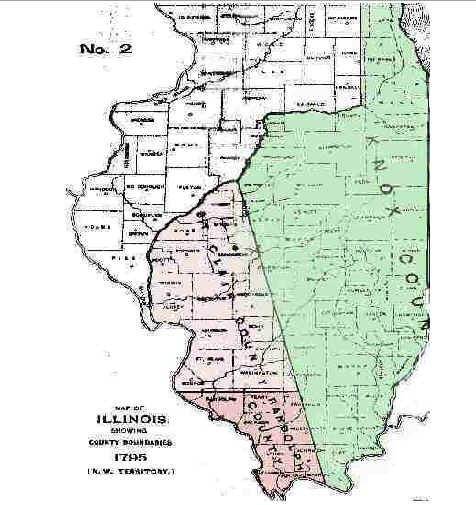
| http://genealogytrails.com/ill/1795randolph.htm |
1795 Randolph
As a County of the Northwest Territory
|
| http://genealogytrails.com/ill/territorialpapers.html |
1818 Jan. 13 - Thomas GREENE, Geo. BROWN &
Rice SAMS - Justices of Peace - Union Co.
1813 Aug. 15 - Thomas GREEN - Justice of Peace -
Johnson Co.
|
| http://genealogytrails.com/ill/slavemap.htm |
Slave Counties
in 1824 Illinois

|
| http://genealogytrails.com/ill/fortsmap.jpg |
Illinois Fort Map

|
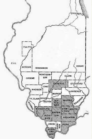
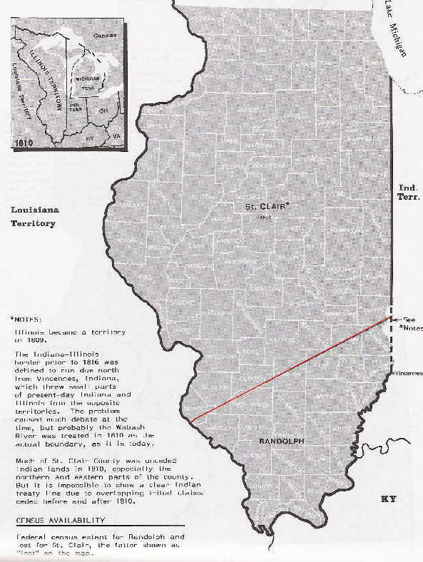
| http://genealogytrails.com/ill/1810map.html |
1810 Map of
Illinois
|
| http://genealogytrails.com/ill/1812map.html |
1812 Map of Illinois Territory
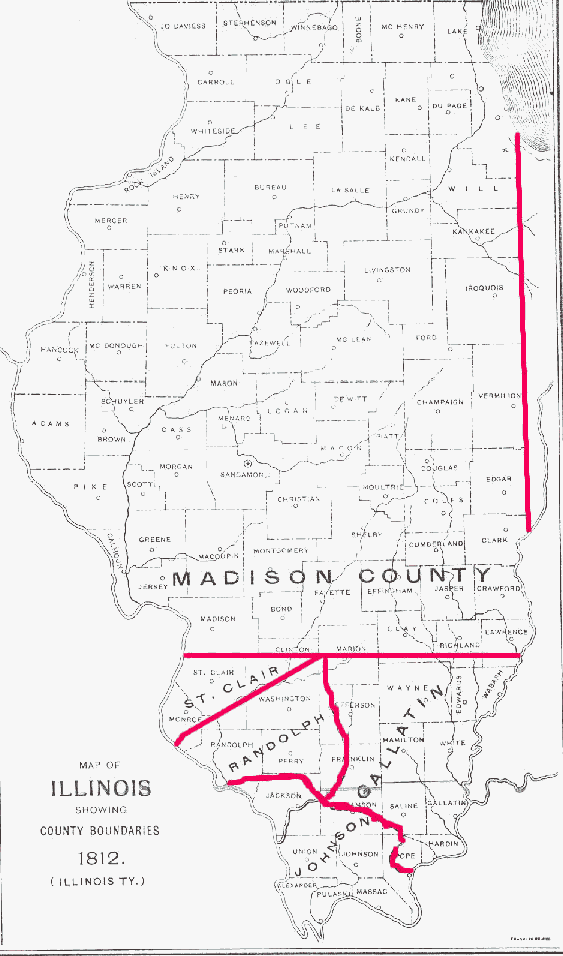 |
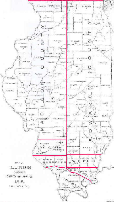
| http://genealogytrails.com/ill/1815map.html |
1815 Map of Illinois Territory
 |
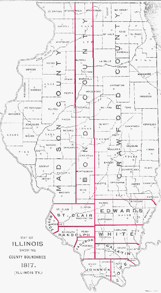
| http://genealogytrails.com/ill/1817map.html |
1817 Map of Illinois Territory
 |
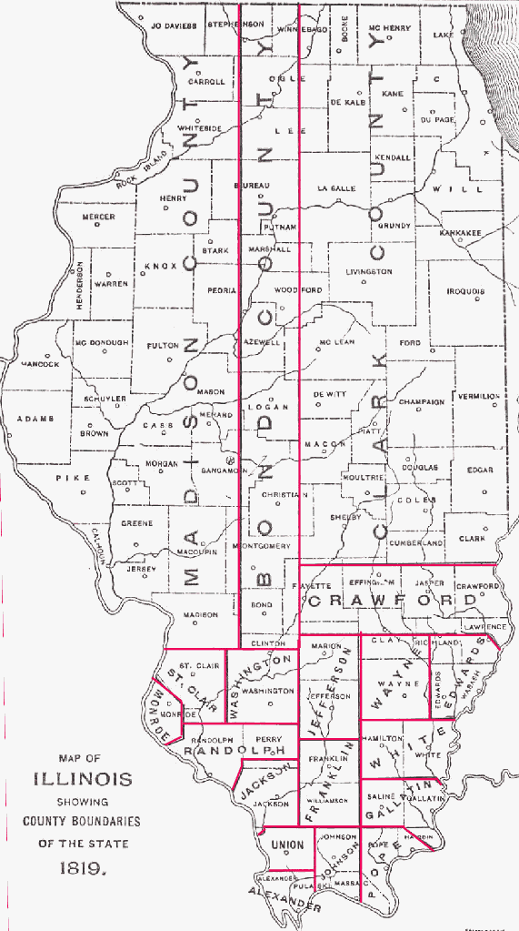
| http://genealogytrails.com/ill/1819map.html |
1819 Map of Illinois Territory
|
| http://genealogytrails.com/ill/1820map.html |
1820 Map of Illinois
 |
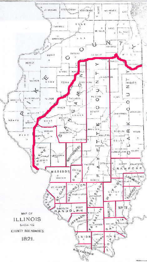
| http://genealogytrails.com/ill/1821map.html |
1821 Map of Illinois Territory
|
| http://genealogytrails.com/ill/slavemap.htm |
Slave Counties
in 1824 Illinois
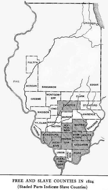
|
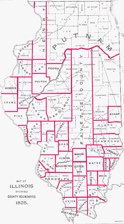
| http://genealogytrails.com/ill/1825map.html |
1825 Map of Illinois Territory
|
| http://genealogytrails.com/ill/1830map.html |
1830 Map of Illinois
|
| http://genealogytrails.com/ill/1835map.html |
1835 Map of Illinois Territory
|
| http://genealogytrails.com/ill/readland.html |
"How to Read Land
Descriptions"
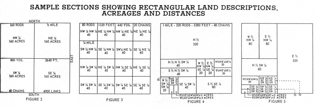

|
| http://www.rootsweb.ancestry.com/~ilgssi/Maps/Union.pdf |
Union County Illinois, January 1818

|
| http://www.rootsweb.ancestry.com/~ilgssi/Maps/Johnson.pdf |
Johnson County Illinois Territory 1812 September
|
| |
1996
Highway Map Union County, Illinois

|
| |
|
| |
|
| http://www.memoriallibrary.com/IL/South/Bios/G/Green~William.htm |
Might this be the William Green family after which William
Green Thornton was named? TCT 21 August 2012
William P.
Green was born October 28, 1854, in Union county, Illinois,
the son of William and Cornelia (Bennett) Green.
Nathaniel Green, the grandfather, an energetic South
Carolinian, came to this county about 1803. He was the father of
Mastin, David and William Green. Mastin and
David were born in South Carolina and William was
born in this county in 1806. The father died here soon after and
the boys located in the Mississippi Bottoms. These brothers are
all dead. p.
610
When they located
in the Mississippi Bottoms they resided for a time with an uncle
who managed Green's Ferry on the Father of Waters. The
boys lived the wholesome, strenuous life of the pioneer, raising
crops in the summer and in the fall and winter going into the
woods where they made a flat-boat on which they floated their
produce down to New Orleans and sold it. They were industrious
and thrifty and in this way accumulated considerable money. In
1844 they were driven out of the bottoms by floods and they went
to the hills. David Green settled on his farm at
Green's Crossing near Cobden and opened a general
merchandise store at that place in 1854. William Green,
father of him whose name inaugurates this review, removed to
Jonesboro and continued farming. He owned a section of land west
of that place, and this he tilled up to the time of his death in
1865. This good man, who was respected and influential in his
community, reared a family of four children. Florence W. born
October 26, 1834, died August 15, 1899. He married Annetta
Cover January 17, 1865, and their surviving children are as
follows: Otis, Daniel, John H., Florence E., James A. and
Roy. Mollie, second of the subject's sisters, married Calvin
Miller first and after his death became the wife of A. C.
Stage, her present residence being in Chicago. The subject
is third in order of birth and the youngest member of the family
is David M., an Arkansas farmer. The father, William
Green Sr., was one of the organizers of the Union County
Agricultural & Mechanical Society, which held the first
county fair in this county. He was a member and deacon in the
Baptist church of Jonesboro and his hand was given to all good
causes. In his time he accumulated considerable wealth. His
wife, whose maiden name was Cornelia Bennett, died in
1855, in the infancy of William, Jr.
|
| |
|
| |
|
| |
|
|

|