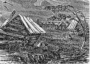
The Great Earthquake at New Madrid, a 19th-century
woodcut
from Devens'
Our First Century (1877)
New Madrid fault and earthquake-prone region considered at
high risk today.
The 1811–1812 New Madrid earthquakes (pronounced /nuː
ˈmædrɨd/) were an intense intraplate
earthquake series beginning with an initial pair of very large
earthquakes on December 16, 1811. These earthquakes remain the most
powerful earthquakes to hit the eastern United States in recorded
history.[1]
These events, as well as the seismic zone of their occurrence, were
named for the Mississippi
River town of New
Madrid, then part of the Louisiana
Territory, now within Missouri.
There are estimates that the earthquakes were felt strongly over
roughly 130,000 square kilometers (50,000 sq mi), and moderately
across nearly 3 million square kilometers (1 million square miles).
The historic 1906
San Francisco earthquake, by comparison, was felt moderately
over roughly 16,000 km2 (6,200 sq mi).
The
1811–1812 earthquakes
The
four earthquakes
- December 16, 1811, 0815 UTC (2:15 a.m.); (M ~7.2 –
8.1[2])
epicenter in northeast Arkansas. It caused only slight damage to
man-made structures, mainly because of the sparse population in
the epicentral area. The future location of Memphis,
Tennessee experienced level IX shaking on the Mercalli
intensity scale. A seismic seiche
propagated upriver, and Little Prairie (a village that was on
the site of the former Fort San Fernando, near the site of
present-day Caruthersville,
Missouri) was heavily damaged by soil
liquefaction.[3]
- December 16, 1811, 1415 UTC (8:15 a.m.); (M ~7.2–8.1)
epicenter in northeast Arkansas. This shock followed the first
earthquake by six hours and was similar in intensity.[2]
- January 23, 1812, 1500 UTC (9 a.m.); (M ~7.0–7.8[2])
epicenter in the Missouri
Bootheel. The meizoseismal
area was characterized by general ground warping, ejections,
fissuring, severe landslides, and caving of stream banks.
Johnson and Schweig attributed this earthquake to a rupture on
the New Madrid North Fault. This may have placed strain on the
Reelfoot Fault.[3]
- February 7, 1812, 0945 UTC (4:45 a.m.); (M ~7.4–8.0[2])
epicenter near New Madrid, Missouri. New Madrid was destroyed.
At St.
Louis, Missouri, many houses were severely damaged, and
their chimneys were toppled. This shock was definitively
attributed to the Reelfoot Fault by Johnston and Schweig. Uplift
along a segment of this reverse
fault created temporary waterfalls on the Mississippi at Kentucky
Bend, created waves that propagated upstream, and caused the
formation of Reelfoot
Lake by obstructing streams in what is now Lake
County, Tennessee.[3]
Susan Hough, a seismologist of the United
States Geological Survey (USGS), has recently estimated the
earthquakes' magnitudes as "right around magnitude 7. Possibly
a bit below, possibly a bit above, but not as big as 7.5."[4]
Eyewitness
accounts
John Bradbury, a Fellow of the Linnean Society, was on the
Mississippi on the night of December 15, 1811, and describes the
tremors in great detail in his Travels in the Interior of America
in the Years 1809, 1810 and 1811, published in 1817.[5]
After supper, we went to sleep as usual: about ten o'clock, and
in the night I was awakened by the most tremendous noise,
accompanied by an agitation of the boat so violent, that it
appeared in danger of upsetting ... I could distinctly see the
river as if agitated by a storm; and although the noise was
inconceivably loud and terrific, I could distinctly hear the
crash of falling trees, and the screaming of the wild fowl on
the river, but found that the boat was still safe at her
moorings. By the time we could get to our fire. which was on a
large flag, in the stern of the boat, the shock had ceased; but
immediately the perpendicular banks, both above and below us,
began to fall into the river in such vast masses, as to nearly
sink our boat by the swell they occasioned ... At day-light we
had counted twenty-seven shocks.
Eliza Bryan[6]
in New Madrid, Territory
of Missouri, wrote the following eyewitness account in March,
1812.
On the 16th of December, 1811, about two o'clock, a.m., we were
visited by a violent shock of an earthquake, accompanied by a
very awful noise resembling loud but distant thunder, but more
hoarse and vibrating, which was followed in a few minutes by the
complete saturation of the atmosphere, with sulphurious vapor,
causing total darkness. The screams of the affrighted
inhabitants running to and fro, not knowing where to go, or what
to do—the cries of the fowls and beasts of every species—the
cracking of trees falling, and the roaring of the Mississippi—
the current of which was retrograde for a few minutes, owing as
is supposed, to an irruption in its bed— formed a scene truly
horrible.
John
Reynolds (February 26, 1788 – May 8, 1865) who was the 4th
governor of Illinois, among other political posts, mentions the
earthquake in his biography My Own Times: Embracing Also the
History of My Life (1855):[7]
On the night of 16th November [sic], 1811, an earthquake
occurred, that produced great consternation amongst the people.
The centre of the violence was in New Madrid, Missouri, but the
whole valley of the Mississippi was violently agitated. Our
family all were sleeping in a log cabin, and my father leaped
out of bed crying aloud "the Indians are on the house"
... We laughed at the mistake of my father, but soon found out
it was worse than the Indians. Not one in the family knew at the
time that it was an earthquake. The next morning another shock
made us acquainted with it, so we decided it was an earthquake.
The cattle came running home bellowing with fear, and all
animals were terribly alarmed on the occasion. Our house cracked
and quivered, so we were fearful it would fall to the ground. In
the American Bottom many chimneys were thrown down, and the
church bell in Cahokia sounded by the agitation of the building.
It is said the shock of an earthquake was felt in Kaskaskia in
1804, but I did not perceive it. The shocks continued for years
in Illinois, and some have experienced it this year, 1855.
The Shaker diarist Samuel Swan McClelland described the effects
of the earthquake on the Shaker settlement at West
Union (Busro), Indiana, where the earthquakes contributed to the
temporary abandonment of the westernmost Shaker community.[8]
Consequence
of the 1811–12 earthquakes
Some sections of the Mississippi River appeared to run backward
for a short time.[3]
Sand
blows were common throughout the area, and can still be seen
from the air in cultivated fields. The shockwaves propagated
efficiently through the firm midwestern bedrock, with residents as
far away as Pittsburgh,
Pennsylvania, and Norfolk,
Virginia, awakened by intense shaking.[9]
Church bells were reported to ring as far as Boston, Massachusetts
and York,
Ontario (now Toronto), and sidewalks were reported to have been
cracked and broken in Washington, D.C.[10]
There were also reports of toppled chimneys in Maine.[citation
needed]
Disaster
relief
A request, dated January 13, 1812, by William
Clark (famous for his exploration of the American West with Meriwether
Lewis and the Corps of Discovery from 1803 to 1805), then the
governor of the Louisiana
Territory (the territory was renamed the Missouri
Territory soon after the quake to eliminate confusion with the
new state of Louisiana),
asked for federal relief for the "inhabitants of New Madrid
County."
Whereas the Catalogue of miseries and afflictions, with which it
has pleased the Supreme Being of the Universe to visit the
inhabitants of the earth there are none more truly awful and
destructive than Earthquakes ... The inhabitants of the late
District now County of New Madrid, in this Territory, have
lately been visited with several calamities of this kind, which
have deluged large portions of their country and involved in the
greatest distress many families, whilst others have been
entirely ruined ... In the opinion of the said General Assembly
provisions ought to be made by law for or cashiered to the said
inhabitants relief, either out of the public fund or in some
other way as may can meet to the cost demand availability of the
General Government.
This is possibly the very first request that the U.S. Federal
Government had received for aid from one of its territories.
Other
The earthquakes helped bring to justice the murderers of George
Lewis (commonly known as "Slave George"). George was
slain on the night of December 15–16, 1811 by two nephews of Thomas
Jefferson, Lilburn Lewis and Isham Lewis, who were also
relatives of Meriwether
Lewis. After killing him with an axe in front of other slaves,
George's owners intended to burn his mutilated corpse, but the first
New Madrid earthquake interrupted their effort, and so the corpse
was interred in a brick chimney. The murder might well have escaped
discovery by authorities, except that the January 23 and February 7
quakes caused the chimney to partially collapse, exposing George's
remains. Lilburn and Isham Lewis were quickly investigated, arrested
and charged. Lilburn killed himself; Isham escaped from jail and
probably died during the War
of 1812.[11][12]
Geologic
setting
The underlying cause of New Madrid earthquakes is not well
understood, but modern faulting seems to be related to an ancient
geologic feature buried under the Mississippi River alluvial plain,
known as the Reelfoot
Rift.
The New Madrid Seismic Zone (NMSZ) is made up of reactivated faults
that formed when what is now North America began to split or rift
apart during the breakup of the supercontinent
Rodinia
in the Neoproterozoic
Era
(about 750 million years ago). Faults were created along the rift
and igneous
rocks formed from magma
that was being pushed towards the surface. The resulting rift system
failed but has remained as an aulacogen
(a scar or zone of weakness) deep underground. Another unsuccessful
attempt at rifting 200 million years ago created additional faults,
which made the area weaker. The resulting geological structures make
up the Reelfoot Rift, and have since been deeply buried by younger
sediments. But the ancient faults appear to have made the rocks deep
in the Earth's crust in the New Madrid area mechanically weaker than
much of the rest of North America.
This weakness, possibly combined with focusing effects from
mechanically stronger igneous rocks nearby, allows the relatively
small east-west compressive forces that exist in the North American
plate to reactivate old faults, making the area prone to
earthquakes.[13]
Since other rifts are known to occur in North America's stress
environment but not all are associated with modern earthquakes, (for
example the Midcontinent
Rift System that stretches from Minnesota
to Kansas),
other processes could be at work to locally increase mechanical
stress on the New Madrid faults. Stress changes associated with
bending of the lithosphere
caused by the melting of continental glaciers at the end of the last
Ice
Age, has been considered to play a role,[14]
as well as downward pull from sinking igneous rock bodies below the
fault.[15]
It has also been suggested that some form of heating in the
lithosphere below the area may be making deep rocks more plastic,
which concentrates compressive stress in the shallower subsurface
area where the faulting occurs.[16]
There may be local stress from a change in the flow of the mantle
beneath the NMSZ, caused by the sinking Farallon
Plate, according to one model.[17]
Seismic zone
When epicenters of modern earthquakes are plotted on a map, three
trends become apparent. First is the general northeast-southwest
trend paralleling the trend of the Reelfoot Rift, in Arkansas, south
of where the epicenters turn northwest. This is a right-lateral strike-slip
fault system parallel to the Reelfoot Rift.
The second is the southeast to northwest trend that occurs just
southwest of New Madrid. This trend is a stepover thrust fault known
as the Reelfoot Fault, associated with the Tiptonville dome and the
impoundment of Reelfoot Lake. Epicenter locations on this fault are
more spread out because the fault surface is inclined and dips into
the ground, towards the south, at around forty degrees. Slip is
towards the northeast. Motion on this fault in the 1811–1812
series created waterfalls on the Mississippi.
The third line, extending northeast from the northwestern end of
the Reelfoot Fault is another right-lateral strike-slip fault,
termed New Madrid North.
The epicenters of over 4,000 earthquakes can be identified from
seismic measurements taken since 1974. It can be seen that the
earthquakes originate from the seismic activity of the Reelfoot
Rift. The zone which is colored in red on the map is called the New
Madrid Seismic Zone.
Recent
earthquakes
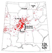
4000 earthquake reports since 1974
The zone remains active today. In recent decades minor
earthquakes have continued.[10]
New forecasts estimate a 7 to 10 percent chance, in the next 50
years, of a repeat of a major earthquake like those that occurred in
1811–1812, which likely had magnitudes of between 7.5 and 8.0.
There is a 25 to 40 percent chance, in a 50-year time span, of a
magnitude 6.0 or greater earthquake.[18]
Recurrence
potential
In a report filed in November 2008, the U.S. Federal
Emergency Management Agency warned that a serious earthquake in
the New Madrid Seismic Zone could result in "the highest
economic losses due to a natural disaster in the United
States," further predicting "widespread and
catastrophic" damage across Alabama, Arkansas, Illinois,
Indiana, Kentucky, Mississippi, Missouri, and particularly
Tennessee, where a 7.7 magnitude quake or greater would cause damage
to tens of thousands of structures affecting water
distribution, transportation
systems, and other vital infrastructure.[19]
The potential for the recurrence of large earthquakes and their
impact today on densely populated cities in and around the seismic
zone has prompted research devoted to understanding in the New
Madrid Seismic Zone. By studying evidence of past quakes and closely
monitoring ground motion and current earthquake activity, scientists
attempt to understand their causes and recurrence intervals.
The lack of apparent land movement along the New Madrid fault
system has long puzzled scientists. In 2009 two studies based on
eight years of GPS measurements indicated that the faults were
moving at no more than 0.2 millimeters (0.0079 in) a year.[20]
In contrast, the rate of slippage on the San
Andreas Fault averages as much as 37 mm (1.5 in) a year across
California.[21]


