|
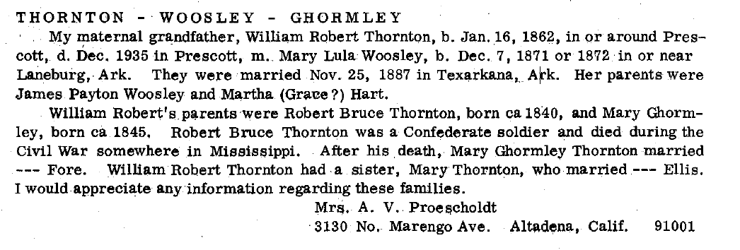
Mary Lula _Woolsey_ Thornton
| |
|
William Thornton (1770 - 1846)
|
|
Information found by TCT 08 January
2013
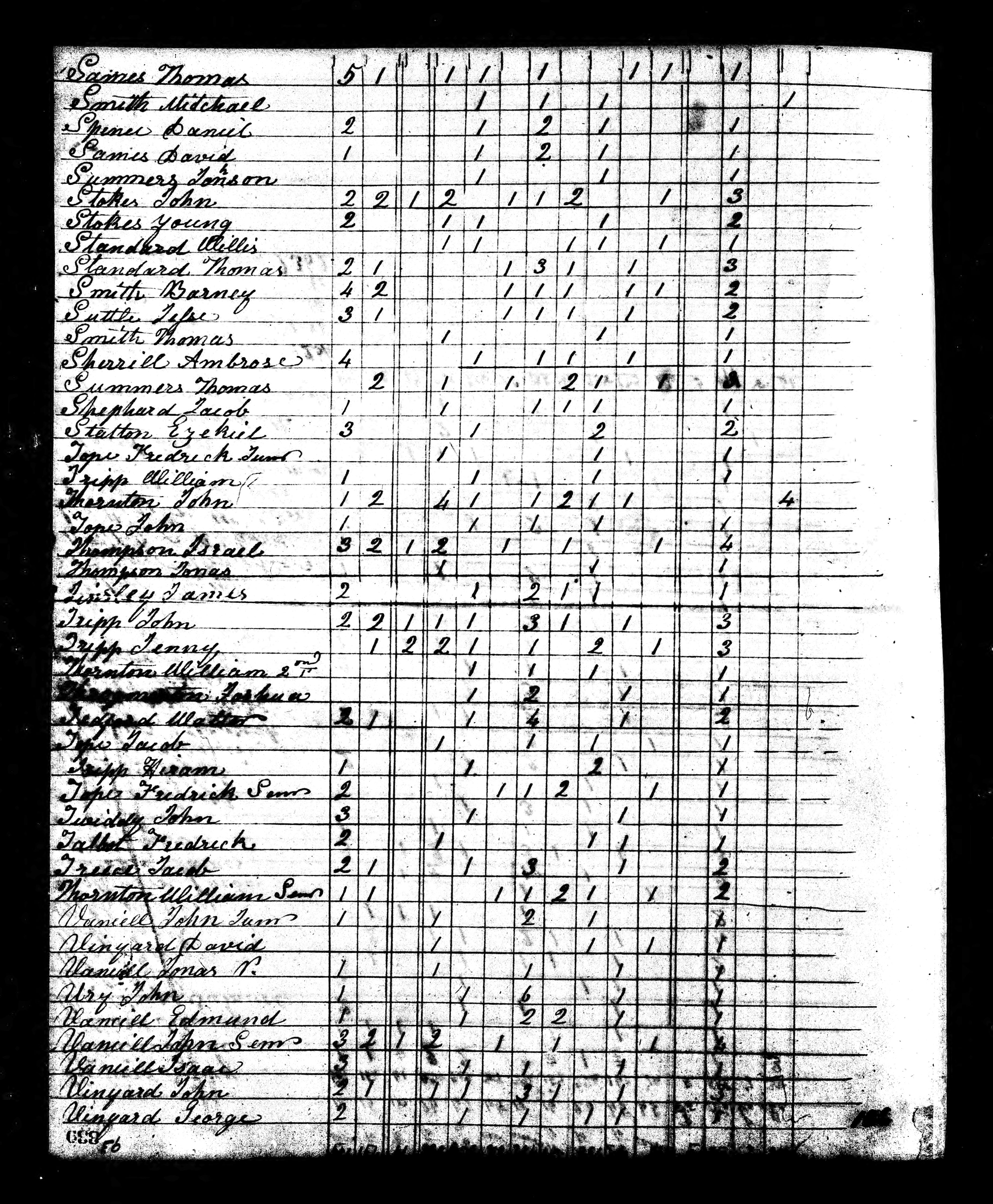
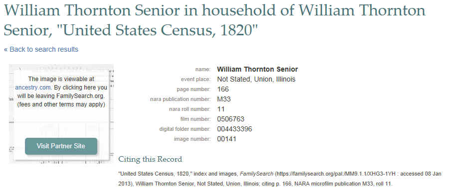
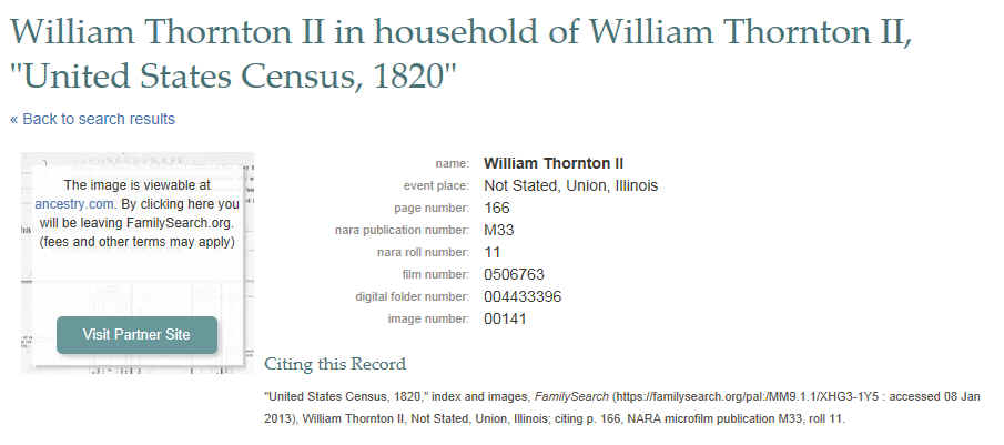
| 1820 United States Federal Census William Thornton Sr and Jr Union County Illinois
http://search.ancestry.com/Browse/print_u.aspx?dbid=7734&iid=4433396_00141&pid=&autoprint=true&imageonly=true&client=SUI&version=AMVLZaDzzgg
|
1820 United States Federal Census William Thornton Sr and Jr Union County Illinois
William Thornton Senior in household of William Thornton
Senior, "United States Census, 1820"
| name: |
William
Thornton Senior |
| event place: |
Not Stated,
Union, Illinois |
| page number: |
166 |
| nara publication
number: |
M33 |
| nara roll number: |
11 |
| film number: |
0506763 |
| digital folder
number: |
004433396 |
| image number: |
00141 |
Citing this Record
"United States Census, 1820," index and images, FamilySearch
(https://familysearch.org/pal:/MM9.1.1/XHG3-1YH : accessed 08
Jan 2013),
William Thornton Senior, Not Stated, Union, Illinois;
citing p. 166, NARA microfilm publication M33, roll 11.
|
| William Thornton II
in household of William Thornton II, "United
States Census, 1820"
https://familysearch.org/pal:/MM9.1.1/XHG3-1Y5
|
William Thornton II in household of William Thornton II,
"United States Census, 1820"
| name: |
William
Thornton II |
| event place: |
Not Stated,
Union, Illinois |
| page number: |
166 |
| nara publication
number: |
M33 |
| nara roll number: |
11 |
| film number: |
0506763 |
| digital folder
number: |
004433396 |
| image number: |
00141 |
Citing this Record
"United States Census, 1820," index and images, FamilySearch
(https://familysearch.org/pal:/MM9.1.1/XHG3-1Y5 : accessed 08
Jan 2013), William Thornton II, Not Stated, Union, Illinois;
citing p. 166, NARA microfilm publication M33, roll 11.
|
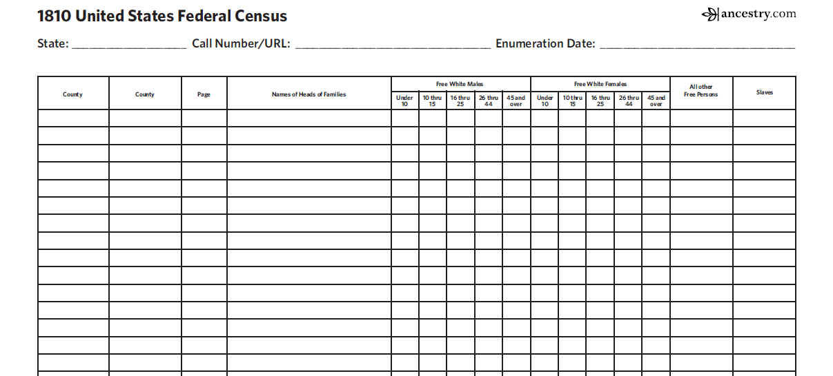
| About 1810 United States Federal Census
http://search.ancestry.com/search/db.aspx?dbid=7613
|
About 1810 United States Federal Census
This database details those persons enumerated in the
1810 United States Federal Census, the Third Census of the
United States. In addition, the names of those listed on
the population schedule are linked to the actual images of
the 1810 Federal Census, copied from the National Archives
and Records Administration microfilm, M252, 71 rolls. (If
you do not initially find the name on the page that you
are linked to, try a few pages forward or backward, as
sometimes different pages had the same page number.)
About the 1810 Census:
The official enumeration day of the 1810 census was 6
August 1810. All questions asked were supposed to refer to
that date. The enumeration was to be completed within nine
months, but the due date was extended by law to ten
months. Schedules exist for 17 states and District of
Columbia, Georgia territory, Mississippi territory,
Louisiana territory, Orleans, Michigan territory, and
Illinois territory. There was, however, a district wide
loss for District of Columbia, Georgia, Indiana Territory,
Mississippi Territory, Louisiana Territory (MO), New
Jersey and Tennessee. Partial losses included Illinois
Territory, which had only two counties (Randolph is
extant, St. Clair is lost.), and OH, all lost except
Washington County. Some of the schedules for these states
have been re-created using tax lists and other records.
Enumerators of the 1810 census were asked to include
the following categories in the census: name of head of
household; number of free white males and females in age
categories: 0 to 10, 10 to 16, 16 to 26, 26 to 45, 45 and
older; number of other free persons except Indians not
taxed; number of slaves; and town or district and county
of residence. The categories allowed Congress to determine
persons residing in the United States for collection of
taxes and the appropriation of seats in the House of
Representatives. Most entries are arranged in the order of
visitation, but some have been rearranged to appear in
alphabetical order by initial letter of the surname.
Manufacturing schedules are scattered among the 1810
population schedules.
|
| |
|
| |
|
Arkansas
Census, 1819-70
about
William Thornton
http://search.ancestry.com/cgi-bin/sse.dll?db=arcen&h=739266&indiv=try&o_vc=Record:OtherRecord&rhSource=7836
|
Arkansas
Census, 1819-70
about
William Thornton
| Name: |
William Thornton |
| State: |
AR |
| County: |
Clark County |
| Township: |
Antoine Township |
| Year: |
1828 |
| Record Type: |
Tax List |
| Database: |
AR 1819-1829 Tax Lists Index |
Source Information:
Jackson, Ron V., Accelerated Indexing Systems, comp.. Arkansas
Census, 1819-70 [database on-line]. Provo, UT, USA: The
Generations Network, Inc., 1999.
Original data: Compiled and digitized by Mr. Jackson and AIS
from microfilmed schedules of the U.S. Federal Decennial
Census, territorial/state censuses, and/or census substitutes.
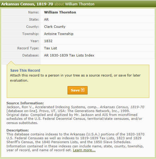
Arkansas
Census, 1819-70
about
William Thornton
http://search.ancestry.com/cgi-bin/sse.dll?db=arcen&h=739268&indiv=try&o_vc=Record:OtherRecord&rhSource=3542
| Name: |
William Thornton |
| State: |
AR |
| County: |
Clark County |
| Township: |
Antoine Township |
| Year: |
1832 |
| Record Type: |
Tax List |
| Database: |
AR 1830-1839 Tax Lists Index |
|
| |
|
U.S.
and International Marriage Records, 1560-1900
about
William Thornton
http://search.ancestry.com/cgi-bin/sse.dll?rank=1&new=1&MSAV=0&msT=1&gss=angs-g&gsfn=William+Robert&gsln=Thornton&mswpn__ftp=Union+County%2c+Illinois%2c+USA&mswpn=2952&mswpn_PInfo=7-%7c0%7c1652393%7c0%7c2%7c3247%7c16%7c0%7c2952%7c0%7c0%7c&msbdy=1775&msbpn__ftp=South+Carolina&msddy=1846&msdpn__ftp=Clark+County%2c+Arkansas%2c+USA&msdpn=6&msdpn_PInfo=5-%7c0%7c1652393%7c0%7c2%7c3246%7c6%7c0%7c0%7c0%7c0%7c&uidh=uv4&mssng0=Mary&mssns0=Woolsey&pcat=ROOT_CATEGORY&h=1218226&recoff=5+6+22&db=WorldMarr_ga&indiv=1
|
U.S.
and International Marriage Records, 1560-1900
about
William Thornton
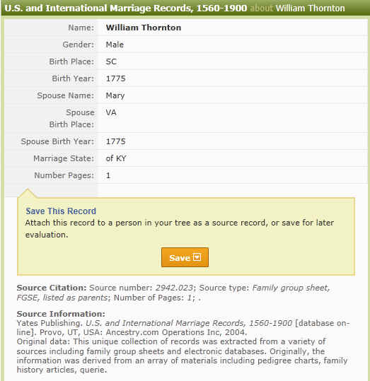
I am not sure if this is our ancestors:
William Robert Thornton and Mary Lula Woolsey? TCT |
| |
|
|
|
Information found by TCT 20 December
2011
|
| William Thornton (1770 - 1846)
http://records.ancestry.com/William_Thornton_records.ashx?pid=41757231 |
Born in Virginia, USA on 1770 to Abraham
Thornton and Elizabeth
Martin.
This information, above, is
suspect. Abraham Thornton family were Quakers and were
evacuated to Nova Scotia after the American Revolution as they
were "loyalists" I cannot find any information
that any of them returned to the US.
William married Mary
Lula Woolsey and had 11 children. He passed away on 28 Mar
1846 in Clark, Arkansas, USA.
|
| http://www.agsgenealogy.org/databases/pdffiles/AFH/AFH091Mar1971.pdf |
This information, above, is
suspect. Is this a descendant of the William Robert
Thornton from South Carolina? and what are the odds of a
Mary Lula Woosley??
|
| |
West
Yorkshire, England, Baptisms, Marriages and Burials, 1512-1812
|
| Elizabeth Martin (1752 - )
http://records.ancestry.com/Elizabeth_Martin_records.ashx?pid=41861143 |
Born on 1752. Elizabeth married Abraham
Thornton and had 5 children.
|
| Abraham Thornton (1745 - 1796)
http://records.ancestry.com/Abraham_Thornton_records.ashx?pid=41894441 |
Born in Orange, North Carolina, USA on 1745 to Thomas
Thornton and Martha
Boykin. Abraham married Elizabeth
Martin and had 5 children. He passed away on 1796 in
Edgefield, South Carolina, USA. |
| |
West
Yorkshire, England, Baptisms, Marriages and Burials, 1512-1812
|
| Thomas Thornton
1698-1762
Thomas
Thornton
http://records.ancestry.com/Thomas_Thornton_records.ashx?pid=37512818 |
Parents Unknown
Spouses & Children
Martha
Boykin
1707-1754
|
| Martha
Boykin
1707-1754
Martha Boykin (1707 - 1754)
Born in England on 1707. Martha married Thomas
Thornton and had 6 children. She passed away on 1754 in
North Carolina, USA.
http://records.ancestry.com/Martha_Boykin_records.ashx?pid=37500359 |
|
|
| Union
county, Illinois history
pdf file on this site
|
Jacob Rantleman, William
Thornton and George
Hunsaker became
the new commissioners
in 1819....
The men who served
as constables,
appointed by the governor
between 1818 and 1820 were John Meneese, William
Shelton,
Samuel Betcher, Sam
Hunsaker, Willie Sams,
Samuel Sprouse, Isaac
Williams, Jessie Doolen, Sam
Hunsaker, Levi T. Holland,
Alfred N.
Dilliard, Squire Bone and William
Thornton....
In 1940 the
county road commissioners
were Mr. Landis, Mr.
Mcintosh, Mr.
Thornton,...
|
|
http://libsysdigi.library.uiuc.edu/OCA/Books2008-07/historyofunionco00leon/historyofunionco00leon_djvu.txt
|
The record of "marks and brands," opened immediately
after the county was organized, shows the following men lived in
Union County and registered a "brand" for his domestic
animals, Jacob Wolf, George Wolf, Edmund Vancil, William Dodd,
Samuel Hun- saker, Michael Lindbaugh, David Brown, William
Thornton, Joseph Hunsaker,...
Those who had entered land that lies within the county up to
and including ISIS were John Yost, Wilkinson Goodwin, George
Hunsaker, William Thornton,
John Hunsaker,...
Roads were also built from Jonesboro to Vienna, Jonesboro to
America, Jonesboro to Cape Girardeau, Jonesboro to Brownsville
in Jackson County and from the mouth of the Big Muddy River to
Golconda. As agriculture and population increased, mill seats
were established and as these came into being, the roads were
made to go past the mills enroute to their destinations. An
"overseer" and "viewer" was appointed over
various sections of the road and the people living within four
or five miles on each side of the roads were required to work on
their construction and maintainance. This work must have been
done without pay since the county records do not show where any
payments were made for this type of work in —7—
thfl early days of the county. Then as now the
"overseers" and "viewers" were changed with
a change of county administration. The following names appeared
in the county records as holding this office, David Arnold,
William Pyle, Ephriam Noel, George Hun- saker, Henry Lamer,
Benjamin Meneese, William Alexander, John Hunsaker, Allen
McKenzie, Nathan Turpin, Will Waford, Alexandei boggs, Aaron
Thornton,...
Jacob Rantleman, William Thornton
and George Hunsaker became the new commissioners in 1819 and
with them appeared many new names in the records...
A tavern in those days was usually in a private home where a
wayfarer might stop and procure drink, food and lodging for
himself and hay and shelter for his horse. The price of these
services was regulated by the county board as has been
mentioned before. Each tavern keeper paid a two dollar license
fee and filed a $100 bond. Later these amounts were increased to
six dollars and three hundred dollars. William Shelton, Robert
Lloyd, Isaac Williams, Sam Putchez, Squire Bone, John Meneese,
Jacob Hybarger, George Smiley, John
Thornton,...
The men who served as constables, appointed by the governor
between 1818 and 1820 were John Meneese, William Shelton, Samuel
Betcher, Sam Hunsaker, Willie Sams, Samuel Sprouse, Isaac
Williams, Jessie Doolen, Sam Hunsaker, Levi T. Holland, Alfred
N. Dilliard, Squire Bone and William
Thornton.
The settlement of what are now Anna Precincts was next in
size to Jonesboro. Here the following men had entered land as
follows:....John Thornton,
80 acres;....
The following men were enlisted from Union County:...Privates,...Azel
Thornton...
Reynolds Precinct grew more than any other river section
during the period between 1835 and 1850. Entries added here were....Ralph
Thornton, 120 acres;...
The additions in Saratoga Precinct were....William
Thornton, 42.19 acres;...
Jonesboro was increased by...Azel
Thornton, 34.25 acres...
In 1940 the county road commissioners were Mr. Landis, Mr.
Mcintosh, Mr. Thornton,...
|
| |
|
| |
|
|
| |
|

Original Settlers of Union
County, Illinois
Preemption before 1817
Illinois Genealogy Trails
Submitted by Jeana
Gallagher
http://genealogytrails.com/ill/union/original%20settlers.html |
"1811"
|
Name
|
Date
|
Location
|
|
Thornton, William
|
18 Jan 1811
|
11-1E Sec 6
|
"1812"
|
Name
|
Date
|
Location
|
|
Brown, John
|
15 Oct 1812
|
unknown
|
|
Hollerman, Jacob
|
8 Feb 1812
|
11-3W Sec 24
|
|
Holleman, Josiah
|
8 Feb 1812
|
unknown poss 13-1W
|
"1814"
|
Name
|
Date
|
Location
|
|
Borera, Stephen
|
23 June 1814
|
11-4W Sec 14
|
|
Brown, George Jr.
|
20 Jan 1814
|
12-1W Sec 19
|
|
Godwin, Wilkerson
|
10 Feb 1814
|
unknown poss 13-1W
|
|
Hunsaker, Jacob
|
3 Jan 1814
|
unknown
|
|
Keath, Elizabeth
|
26 Feb 1814
|
13-2W Sec 19/20
|
|
Lawrence, William
|
9 Sept 1814
|
13-2W Sec 36
|
|
McBride, Micajah
|
1 Oct 1814
|
13-1W Sec 34
|
|
McBride, Richard
|
1 Oct 1814
|
12-1W Sec 20
|
|
Stalcup, Peter
|
26 Feb 1814
|
11-3W Sec 15
|
there are more names |
|
Union
County History
http://genealogytrails.com/ill/union/index.html |
Source: HISTORY OF ALEXANDER,
UNION AND PULASKI COUNTIES, ILLINOIS, Edited by William Henry
Perrin, Chicago: O. L. Baskin and Company, Historical
Publishers, 183 Lake Street, 1883, pgs 266, 270, 285, 357.
In the year 1803--just 80 years
ago--the first white settlement was made in the territory now
comprising Union County. Two families, Abram Hunsaker and
George Wolf, came down the Ohio River and up the Cache,
hunting and fishing and finally started on an overland route.
They camped one night a short distance from where Jonesboro
now is. They found game and water plentiful and got busy
building cabins.
In the year 1809 in the south part
of what is now Union County, three families named Lawrence and
the William Clapp family settled on Mill Creek. In a short
time after this, Stokes settlement was occupied by John
Stokes, William Gwinn, George Evans and Thomas Standard.
The act creating Union County
bears the date of January 2, 1818. It is entitled, "An
act adding a part of Pope County to Johnson County, and
forming a new county out of Johnson County."
The site where Jonesboro now
stands was selected in the Spring of 1816 and so named for a
Dr. Jones. Another site for a county seat was selected, but
quite a contest sprung up and the Commissioners selected the
site of John Grammer's farm.
More
Early History
|
| |
|
| |
|
|
| |
|
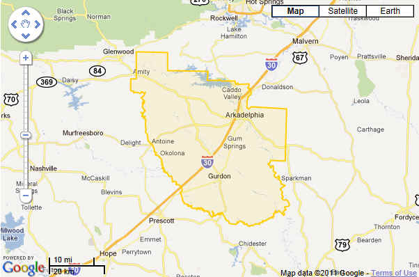
Prescott, Arkansas
|
| |
| |
|
History of Territories and States
Visited by Thornton Family
|
History of South Carolina
https://wikimediafoundation.org/w/index.php?title=L11_1116_RPFP-orig_US/en/US&utm_source=B11_1116_RapidTestAB_btPf&utm_medium=sitenotice&utm_campaign=C11_1116_RapidTestAB_US&language=en&uselang=en&country=US&referrer=http%3A%2F%2Fen.wikipedia.org%2Fwiki%2FHistory_of_South_Carolina
South
Carolina is one of the 13
original colonies of the United
States. European
exploration began in 1540, but the explorers brought
European diseases that decimated the local Indian population. It
was founded in 1663. The English colony of the Province
of Carolina was started in Charleston
in 1670, with wealthy planters and their slaves, coming from the
British Caribbean colony of Barbados.
Colonists overthrew the proprietors after the Yamasee
War, pushing back the American Indians in 1715-1717. In 1719
the colony was officially made a crown
colony, and North
Carolina was split off and made into a separate colony in
1729.
South Carolina banded together with the other colonies to
oppose British taxation in the Stamp Act Crisis of 1765, and
played a major role in resisting Britain. It became independent
in March 1776 and joined the United States of America.[1][2]
The Revolution was bloody and hard fought in 1780-81, as the
British invaded, captured the American army and finally was
driven out.
Colonial
period
By the end of the 16th century, the Spanish and French had
left the area of South
Carolina after several reconnaissance missions and failed colonization
attempts. In 1629, Charles
I, King of England,
granted his attorney general a charter to everything between
latitudes 36 and 31. He called this land the Province of Carlana,
which would later be changed to "Carolina" for
pronunciation, after the Latin
form of his own name.
In 1663, Charles
II gave the land to eight nobles, the Lords
Proprietors, who ruled the Province
of Carolina as a proprietary colony. After the Yamasee
War of 1715-1717, the Lords Proprietors came under
increasing pressure and were forced to relinquish their charter
to the Crown in 1719. The proprietors retained their right to
the land until 1719, when the colony was officially split into
the provinces of North
Carolina and South
Carolina, crown colonies.
In April 1670 settlers arrived at Albemarle Point, at the
junction of the Ashley
River and Cooper
River. They founded Charles
Town, named in honor of King Charles II. Throughout the Colonial
Period, the Carolinas participated in many wars against the
Spanish and the Native
Americans, including the Yamasee
and Cherokee
tribes. In its first decades, the colony's plantations were
relatively small and its wealth came from Indian trade, mainly
in Indian
slaves and deerskins.
The slave trade affected tribes throughout the Southeast, and
historians estimate that Carolinians exported 24,000-51,000
Indian slaves from 1670–1717, sending them to markets ranging
from Boston
to the Barbados.[5]
Planters financed the purchase of African slaves by their sale
of Indians.
18th century
In the 1700-1770 era the colony possessed many advantages -
entrepreneurial planters and businessmen, a major harbor,
cost-efficient African slave labor and an attractive physical
environment, with rich soil and a long growing season, albeit
with endemic malaria. It became one of the wealthiest of the
British colonies. Rich colonials became avid consumers of
services from outside the colony, such as mercantile services,
medical education, and legal training in England. Almost
everyone in 18th-century South Carolina felt the pressures,
constraints, and opportunities associated with the growing
importance of trade.[6]
Yamasee war
A pan-Indian alliance rose up against the settlers in the Yamasee
War (1715–1717) and nearly destroyed the colony. But the
Yamasee were defeated and with exposure to European infectious
diseases, the backcountry's Yamasee population was greatly
reduced.[7]
Slaves
After the Yamasee war, the planters turned exclusively to
importing African slaves for labor. They used their labor to
create rice and indigo plantations as commodity crops. Building
dams, irrigation ditches and related infrastructure, enslaved
Africans created the equivalent of huge earthworks
to regulate water for the rice culture.
The Gullah
people comprised a large fraction of the enslaved people who
were brought to South Carolina. The distinctive Gullah/Geechee
culture was a product not of isolation, but rather of
interaction with American society with non-African alternatives
in full view. The Gullah adapted to multiple factors in American
society, while at the same time marketing or otherwise using
their distinctive lifeways, products, and language to perpetuate
their unique ethnic and racial identity.[8]
Low Country
The Low
Country was settled first, dominated by wealthy men who
became owners of large amounts of land on which they created plantations.[9]
They first transported white indentured
servants as laborers, mostly teenage youth from England who came
to work off their passage in hopes of learning to farm and
buying their own land. Planters also imported African laborers
to the colony. In the early colonial years, social boundaries
were fluid between indentured laborers and slaves, and there was
considerable intermarriage. Gradually the terms of enslavement
became more rigid and slavery became a racial caste. With a
decrease in English settlers as the economy improved in England
before the beginning of the 18th century, the planters began to
rely chiefly on enslaved Africans for labor.
The market for land functioned efficiently and reflected both
rapid economic development and widespread optimism regarding
future economic growth. The frequency and turnover rate for land
sales were tied to the general business cycle; the overall trend
was upward, with almost half of the sales occurring in the
decade before the American Revolution. Prices also rose over
time, parallel with the rise in the price for rice. Prices
dropped dramatically, however, in the years just before the war,
when fears arose about future prospects outside the system of
English mercantilist trade.[10]
Back country
In contrast to the Tidewater, the back country was settled
chiefly by Scots-Irish
and North British migrants who had quickly moved down from Pennsylvania
and Virginia.
The immigrants from Ulster, the Scottish lowlands and the north
of England (the border counties) comprised the largest group
from the British Isles before the Revolution. They came mostly
in the 18th century, later than other colonial immigrants. Such
"North Britons were a large majority in much of the South
Carolina upcountry." The character of this environment was
"well matched to the culture of the British
borderlands." [11]
Such immigrants settled in the backcountry throughout the South
and relied on subsistence farming. They mostly did not own
slaves. Given the differences in background, class,
slaveholding, economics and culture, there was longstanding
competition between the Low Country and Upcountry that played
out in politics.
Revolutionary
War
John Rutledge had many roles in South Carolina's history
throughout the American Revolution.
Main article: South
Carolina during the American Revolution
Prior to the American
Revolution, the British
began taxing American colonies to raise revenue.
Residents of South Carolina were outraged by the Townsend Acts
that taxed tea, paper, wine, glass, and oil. To protest the
Stamp Act, South Carolina sent wealthy rice planter Thomas
Lynch, twenty-six-year-old lawyer John
Rutledge, and Christopher
Gadsden to the Stamp
Act Congress, held in 1765 in New York. Other taxes were
removed, but tea taxes remained. Soon South like the Boston
Tea Party, began to dump tea into the Charleston Harbor,
followed by boycotts
and protests.
South Carolina set up its state government and constitution
on March 26, 1776. Because of the colony's longstanding trade
with Great Britain, the Low Country cities had numerous
Loyalists. Many of the battles fought in South Carolina during
the American Revolution were against loyalist
Carolinians and the Cherokee tribe allied with the British. This
was to British General Henry
Clinton's advantage, as his strategy was to march his troops
north from St.
Augustine and sandwich George
Washington in the North. Clinton alienated Loyalists and
enraged Patriots
by attacking and nearly annihilating
a fleeing army of Patriot soldiers who posed no threat.
White colonists were not the only ones with a desire for
freedom. Estimates are that about 25,000 slaves escaped,
migrated or died during the disruption of the war, 30 percent of
the state's slave population. About 13,000 joined the British,
who had promised them freedom if they fought with them. From
1770 to 1790, the proportion of the state's population made up
of blacks (almost all of whom were enslaved), dropped from 60.5
percent to 43.8 percent.[17]
On October 7, 1780, at Kings
Mountain, John Sevier and William Campbell, assaulted the
'high heel' of the wooded mountain, the smallest area but
highest point, while the other seven groups, led by Colonels
Shelby, Williams, Lacey, Cleveland, Hambright, Winston and
McDowell attacked the main Loyalist position by surrounding the
'ball' base beside the 'heel' crest of the mountain. North and
South Carolinians and attacked British Major Patrick
Ferguson and his body of Loyalists on a hilltop. This was a
major victory for the patriots, especially because it was won by
militiamen
and not trained Continentals. Thomas Jefferson called it
"The turn of the tide of success."[18]
It was the first patriot victory since the British had taken
Charleston. While tensions mounted between the Crown and the
Carolinas, some key southern Pastors became a target of King
George: "...this church (Bullock Creek) was noted as one of
the "Four Bees" in King George's bonnet due to its
pastor, Rev. Joseph Alexander, preaching open rebellion to the
British Crown in June 1780. Bullock Creek Presbyterian Church
was a place noted for being a Whig party stronghold. Under a
ground swell of such Calvin protestant leadership, South
Carolina moved from a back seat to the front in the war against
tyranny. Patriots went on to regain control of Charleston
and South Carolina with untrained militiamen by trapping Colonel
Banastre
"No Quarter" Tarleton's troops along a river.
In 1787, John
Rutledge, Charles
Pinckney, Charles
Cotesworth Pinckney, and Pierce
Butler went to Philadelphia where the Constitutional
Convention was being held and constructed what served as a
detailed outline for the U.S.
Constitution. The federal Constitution was ratified by the
state in 1787. The new state constitution was ratified in 1790
without the support of the Upcountry.
Scots Irish
During the American
Revolution the Scots Irish in the back country in most
states were noted as strong patriots. One exception was the
Waxhaw settlement on the lower Catawba River along the North
Carolina-South Carolina boundary, where Loyalism
was strong. The area experienced two main settlement periods of
Scotch Irish. During the 1750s-1760s, second- and
third-generation Scotch Irish Americans moved from Pennsylvania,
Virginia, and North Carolina. This particular group had large
families, and as a group they produced goods for themselves and
for others. They generally were patriots.
Just prior to the Revolution, a second stream of immigrants
came directly from northern Ireland via Charleston. This group
was forced to move into an underdeveloped area because they
could not afford expensive land. Most of this group remained
loyal to the crown or neutral when the war began. Prior to Charles
Cornwallis's march into the backcountry in 1780, two-thirds
of the men among the Waxhaw settlement had declined to serve in
the army. British victory at the Battle of the Waxhaws resulted
in anti-British sentiment in a bitterly divided region. While
many individuals chose to take up arms against the British, the
British themselves forced the people to choose sides.[19]
|
|
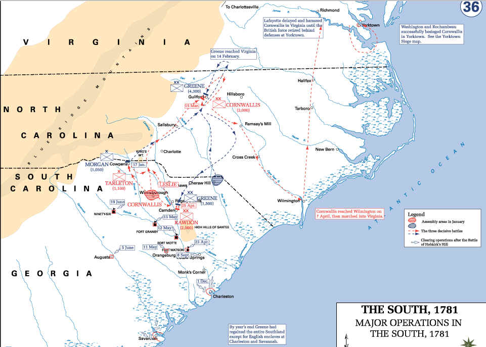
http://upload.wikimedia.org/wikipedia/en/d/d2/Revolutionary_War_-_Major_Operations_in_the_South_1781.Dean.USMA.edu.history.gif
|
 |
|
pdf file on this web site
http://www.clemson.edu/caah/cedp/cudp/pubs/lambert/lambert.pdf
|
South Carolina Loyalists in the American Revolution |
|
http://www.earlyamerica.com/review/2002_summer_fall/pows.htm
|
-Rebel- Prisoners Detained in North America
John Thornton envoy to England |
|
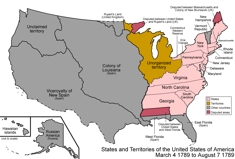
United States 1789-03-1789-08
http://en.wikipedia.org/wiki/File:United_States_1789-03-1789-08.png
|
 |
|
Territorial
evolution of the United States
http://en.wikipedia.org/wiki/Territorial_evolution_of_the_United_States
|
- March 4, 1789
The United
States Constitution came into effect, forming the new
nation. Note that the states ratified at different times, but to
simplify the map, the final result is shown here.
The United States achieved independence from the Kingdom
of Great Britain with the Treaty
of Paris on September 3, 1783, which established that the
thirteen colonies were sovereign and independent states. The
borders were established by Article 2 of the treaty, but with a
couple of issues. First, it stated that the border would run
west from the Lake
of the Woods to the Mississippi
River - at the time, it was not known that the headwaters of
the Mississippi lay south of such a line, so the border has
since been taken to run south from the lake to the river.[3]
Some peculiarities to point out to those familiar only with
the current borders: Many states had sea-to-sea
grants from the British crown that they would not give up
easily, so prior to this date, they ceded
this land to the federal government in exchange for their Revolutionary
War debts. However, Georgia
did not do so until much later, and Connecticut
ceded most land but kept its Western
Reserve. Virginia ceded its claim to the territory north and
west of the Ohio
River, and this land became unorganized
territory. North
Carolina also ceded its claim to its western counties, but
this was not officially accepted by Congress until 1790. New
York ceded its claim on the Erie
Triangle to the federal government. At this point in
history, all of the states except for Georgia and Virginia were
at their present-day borders, except for some of the minor
issues mentioned above.
West
Florida claimed a border further north than what the United
States said it had. Its border had been 31° north when Spain
ceded it to the United
Kingdom. The British later moved its border north to 32°38′
latitude, but when Spanish
Florida was ceded back to Spain
in the Treaty
of Paris, the British cited the original border at the 31st
parallel north, but Spain continued to claim the higher
border.[4]
Also, the borders at the northern area of the Maine
District of Massachusetts
and the area northwest of Lake
Superior remained disputed.
The
Wedge, disputed since the 17th century, remained a point of
contention between Delaware
and Pennsylvania.
The Vermont
Republic was a complex matter, with areas being claimed by New
York and New
Hampshire, but it existed as a de
facto unrecognized independent state.
- August 7, 1789
The United States Congress affirmed the organization of the
Territory North West of the Ohio River, or Northwest
Territory, under the terms of the Northwest
Ordinance.[5]
Northwest Territory consisted of present-day Illinois,
Indiana,
Michigan,
northeastern Minnesota,
most of Ohio,
and Wisconsin.
The Northwest Territory had previously been organized under the Articles
of Confederation on July 13, 1787, and was slightly modified
under the new Constitution.
|
|
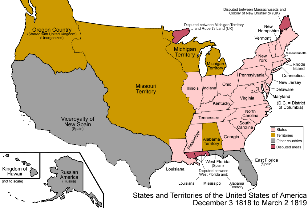
United
States 1818-12-1819-03
http://en.wikipedia.org/wiki/Territorial_evolution_of_the_United_States
|
- December 3, 1818
The southern portion of Illinois
Territory was admitted as the 21st state, Illinois.
The remainder was reassigned to Michigan
Territory. The unorganized lands which had been a part of Indiana
Territory prior to the admission of Indiana
as a state were also assigned to Michigan Territory.

|
|
United States 1819-03-1819-12
|
- March 2, 1819
The southern part of Missouri
Territory was organized as Arkansaw
Territory, consisting of present-day Arkansas
as well as part of Oklahoma.[27]
It was not officially spelled Arkansas until later.

|
|
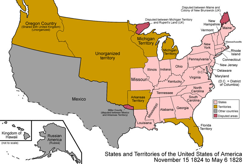
United States 1824-1828
http://en.wikipedia.org/wiki/File:United_States_1824-1828.png
|
- November 15, 1824
Arkansas
Territory was shrunk, the western portion becoming
unorganized.[
|
|
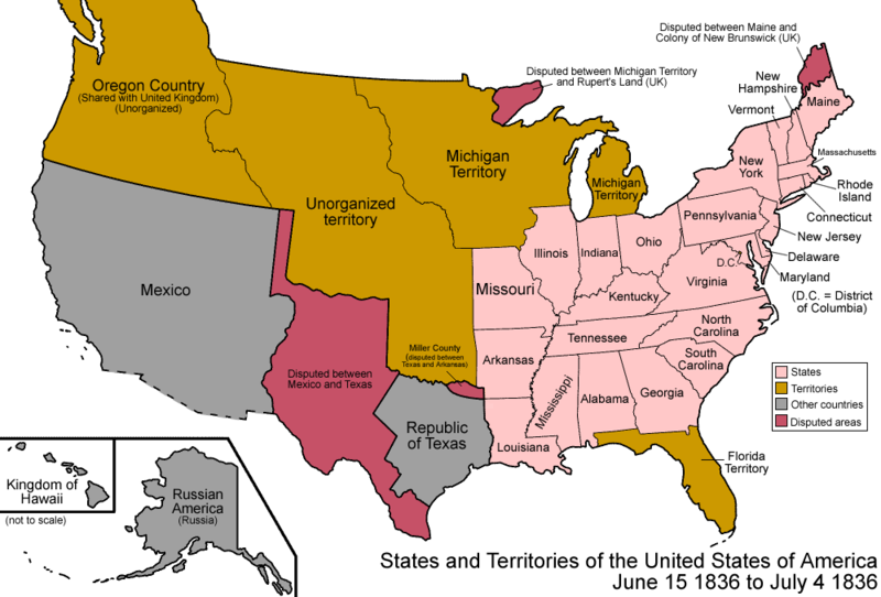
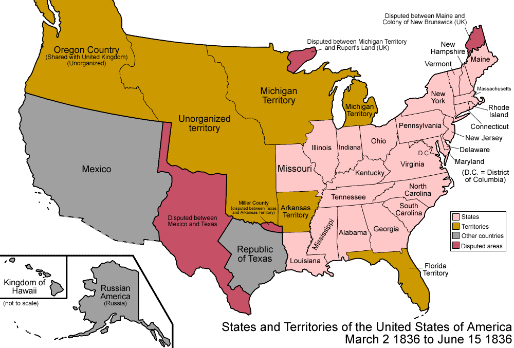
United States 1836-03-1836
http://en.wikipedia.org/wiki/File:United_States_1836-03-1836-06.png
|
- March 2, 1836
The Republic
of Texas achieved independence from Mexico,
though with a large portion of the territory disputed. It had
control over the eastern half of present-day Texas,
and disputed the western half, as well as portions of Colorado,
Kansas,
New
Mexico, and Wyoming.
Miller
County in Arkansas
Territory now intruded on the borders of Texas, and the
people there began to take a Texian identity, leading to both
governments having representatives from the county

|
|
United States 1836-06-1836-07
|
- June 15, 1836
Arkansas
Territory was admitted as the 25th state, Arkansas.
It continued to claim Miller
County, with increasing irrelevance
|
|
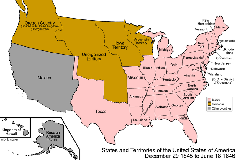
United States 1845-12-1846-06
http://en.wikipedia.org/wiki/File:United_States_1845-12-1846-06.png
|
- December 29, 1845
The Republic
of Texas was admitted as the 28th state, Texas.
The United
States Congress passed the joint
resolution of annexation on March 1, 1845,[37]
but Texas did not agree to join the union for some time after.
Although the annexation resolution avoided specifying Texas's
boundaries, the U.S. inherited Texas's unenforced claims to South
Texas, West
Texas, over half of New
Mexico, a third of Colorado,
and small parts of Oklahoma,
Kansas
and Wyoming.
With Texas joining the union, Arkansas
finally gave up its claim on Miller
County.
|
|
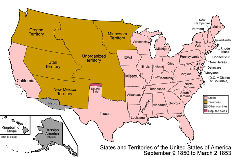
United States 1850-1853-03
http://en.wikipedia.org/wiki/File:United_States_1850-1853-03.png
|
- September 9, 1850
The Compromise
of 1850 divided the Mexican
Cession and land claimed by Texas
but ceded to the federal government in exchange for taking on
its debts. The western portion was admitted as the 31st state, California,
most of the rest was organized as Utah
Territory and New
Mexico Territory, and a small portion became unorganized
land.[43]
New Mexico Territory consisted of most of present-day Arizona
and New
Mexico, as well as a southern portion of Colorado
and the southern tip of Nevada.
Utah Territory consisted of present-day Utah,
most of Nevada, and portions of Colorado and Wyoming.
A peculiarity appeared at this time, when a small strip of land
north of Texas was not officially assigned by any state or
territory; this came to be called the Neutral
Strip or "No Man's Land", which corresponds to the
present-day panhandle
of Oklahoma.
|
|
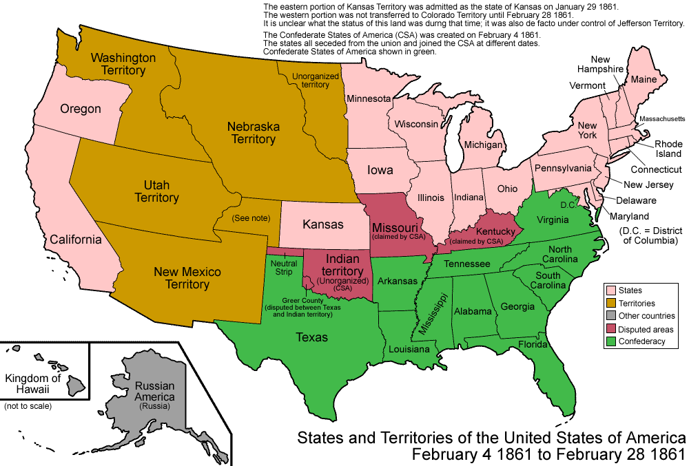
United States 1861-02-04-1861-02
http://en.wikipedia.org/wiki/File:United_States_1861-02-04-1861-02-28.png
|
- February 4, 1861
The Confederate
States of America (CSA) was formed. The Southern
states seceded
at different dates and joined the CSA at different dates; to
simplify the map, only the final form of the CSA is shown here.
There were rebel
governments as well as Union
governments in Kentucky
and Missouri,
and the CSA had full control over Indian
Territory. To view a detailed animated map depicting the
various state secessions see CSA
states evolution.

|
|
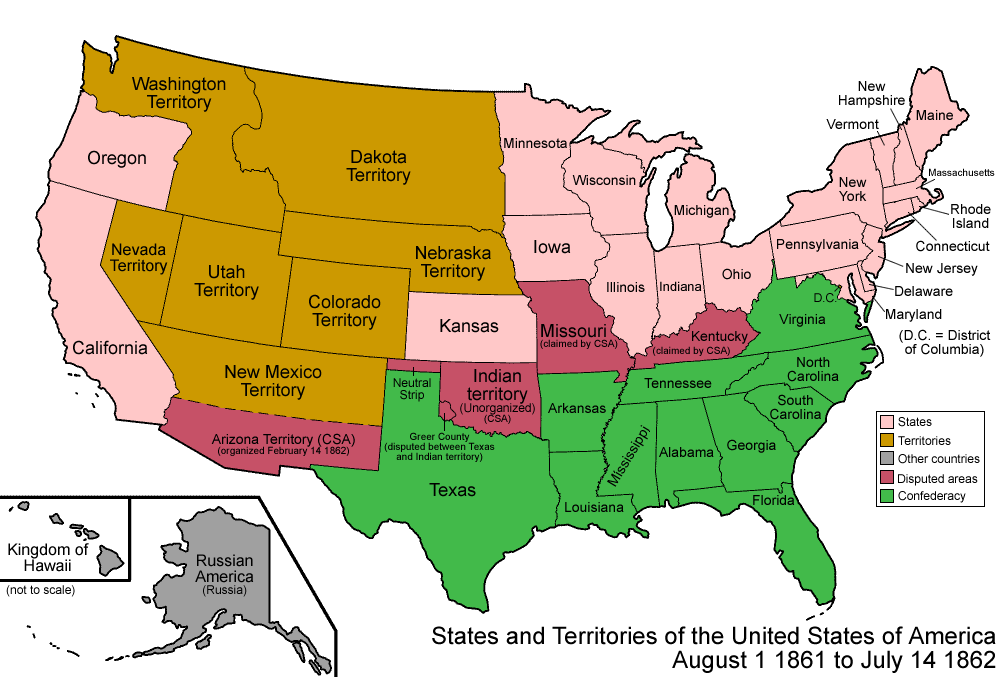
United States 1861-08-1862
http://en.wikipedia.org/wiki/File:United_States_1861-08-1862.png
|
- August 1, 1861
The Confederacy
established Arizona
Territory (CSA) in the southern half of the Union's New
Mexico Territory. It would be organized on February 14,
1862. It corresponded to the southern halves of present-day Arizona
and New
Mexico

|
|
United States 1863-02-1863-03
http://en.wikipedia.org/wiki/File:United_States_1861-08-1862.png
|
- February 24, 1863
The Union created its own Arizona
Territory, splitting it off from New
Mexico Territory, making both territories correspond to
their present-day states, except for Arizona Territory including
the southern tip of present-day Nevada

|
|
United States 1865-1866
http://en.wikipedia.org/wiki/File:United_States_1861-08-1862.png
|
- April 9, 1865
The main
army of the Confederate
States of America surrendered,
and the Confederacy dissolved soon afterward. Much of the
Confederate States' territory had already been retaken by force
of arms prior to this point and the process of Reconstruction
and readmission to the union would take several years following
the Confederacy's collapse; to simplify the map, the former
Confederate states are shown as already readmitted. To view a
detailed animated map depicting the various state readmission
during Reconstruction see CSA
states evolution.

|
|
http://en.wikipedia.org/wiki/File:United_States_1861-08-1862.png
|
- January 14, 1963
The Chamizal
Dispute with Mexico over about 600 acres (2.4 km2) on the
U.S.-Mexico border between El Paso, Texas, and Ciudad Juárez,
Chihuahua is resolved. It was caused by differences between the
bed of the Rio Grande as surveyed in 1852 and the present
channel of the river.
- 1970
The city of Rio
Rico, Texas, was ceded to Mexico
in the Boundary
Treaty of 1970. The handover officially took place in 1977
and the city was added to the Mexican
state of Tamaulipas.
|
|
|
Arkansas Maps
1895 U.S. Atlas
http://www.livgenmi.com/1895/ |
|
|
|
1895 ARKANSAS
INDEX TO CITIES & TOWNS
http://www.livgenmi.com/1895/AR/Index/
| http://www.livgenmi.com/1895/AR/Index/h.htm
|
COUNTY
SEATS IN CAPS
City
or Town Name
|
Population
|
County
|
Area
of State
|
Has
Post Office?
|
Has
Railroad?
|
Has
Express Office?
|
| Hope |
1937 |
Hempstead |
Southwest |
Yes |
Yes |
Yes |
|
| http://www.livgenmi.com/1895/AR/Index/l.htm |
COUNTY
SEATS IN CAPS
City
or Town Name
|
Population
|
County
|
Area
of State
|
Has
Post Office?
|
Has
Railroad?
|
Has
Express Office?
|
| LITTLE
ROCK |
25874 |
Pulaski |
Central |
Yes |
Yes |
Yes |
|
| http://www.livgenmi.com/1895/AR/Index/o.htm |
COUNTY
SEATS IN CAPS
City
or Town Name
|
Population
|
County
|
Area
of State
|
Has
Post Office?
|
Has
Railroad?
|
Has
Express Office?
|
| Okolona |
400 |
Clark |
Southwest |
Yes |
No |
No |
| Olmstead |
|
Pulaski |
Central |
Yes |
No |
No |
|
| http://www.livgenmi.com/1895/AR/Index/p.htm |
COUNTY
SEATS IN CAPS
City
or Town Name
|
Population
|
County
|
Area
of State
|
Has
Post Office?
|
Has
Railroad?
|
Has
Express Office?
|
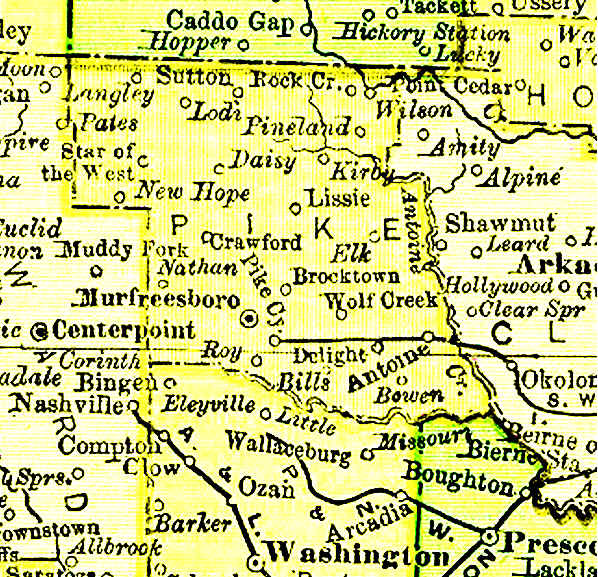
| PRESCOTT |
1287 |
Nevada |
Southwest |
Yes |
Yes |
Yes |
|
| http://www.livgenmi.com/1895/AR/Index/t.htm |
COUNTY
SEATS IN CAPS
City
or Town Name
|
Population
|
County
|
Area
of State
|
Has
Post Office?
|
Has
Railroad?
|
Has
Express Office?
|
| TEXARKANA |
3528 |
Miller |
Southwest |
Yes |
Yes |
Yes |
| Thornton |
406 |
Calhoun |
South |
Yes |
Yes |
Yes |
|
| http://www.livgenmi.com/1895/AR/Index/w.htm |
COUNTY
SEATS IN CAPS
City
or Town Name
|
Population
|
County
|
Area
of State
|
Has
Post Office?
|
Has
Railroad?
|
Has
Express Office?
|
| WASHINGTON |
519 |
Hempstead |
Southwest |
Yes |
Yes |
Yes |
| Woolsey |
|
Washington |
Northwest |
No |
Yes |
Yes |
|
| |
|
|
|
|
|
In 1803, the Louisiana
Purchase was acquired by the United States, and, in 1819, Arkansas was
organized as a territory. Its northern, eastern and southern borders were
the same as they are now, but to the west, some of what is now Oklahoma
was included. Two years later, in 1821, the territorial capital was moved
from Arkansas Post to Little Rock.
By 1836, the
Arkansas Territory had the 60,000 residents required to become a state,
and after writing an acceptable constitution, was declared the 25th state
in the United States.
At the approach of
the Civil War it was one of several states that seceded from the Union in
May of 1861. When the war ended, Arkansas was readmitted in 1868. Like
most southern states, the reconstruction period for Arkansas was
turbulent. The depression of the 1930s hurt the state's cotton economy and
many farmers left. The second world war brought further population loss as
men went to work in war factories in other parts of the country but the
war promoted new industries within the state and especially aluminum
related businesses.
The Capitol of
Arkansas is Little Rock. The Arkansas economy today is dominated by
agriculture. Cotton, soybeans, corn and rice are a few of the successful
crops grown in the region. The State Bird of Arkansas is the Mockingbird
and the State Flower is the Apple Blossom.
http://www.argenweb.net/ |
|
http://www.tngenweb.org/maps/tanner-ar-1832.jpg
Arkansas
County May 1832 |
 |
| |
| http://www.histopolis.com/Place/US/AR/Hempstead_County
|
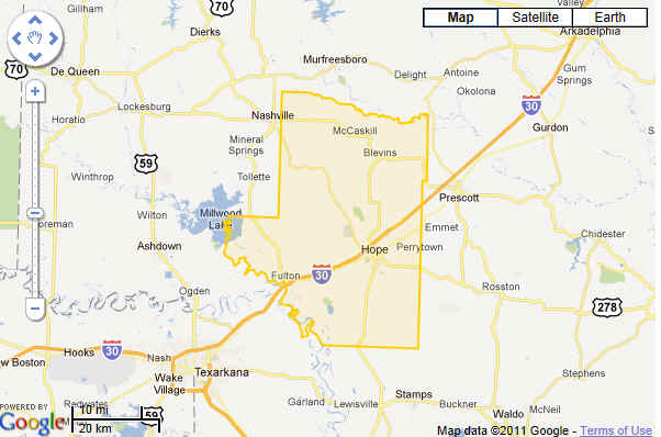
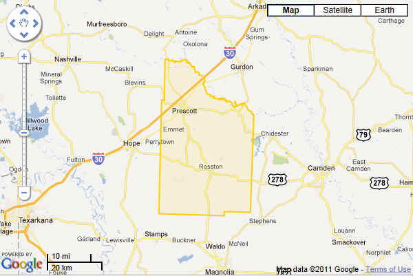
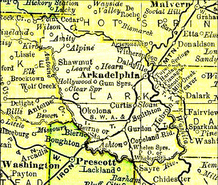
| Clark County, Arkansas, United States
http://www.histopolis.com/Place/US/AR/Clark_County
Details for Clark County
|
|
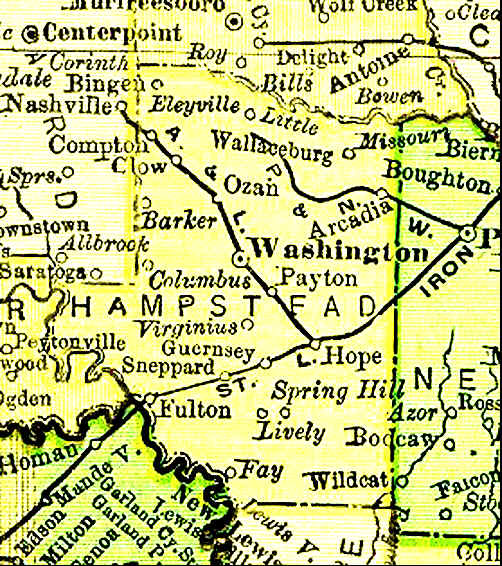
| Hempstead County, Arkansas, United States
Details for Hempstead County
|
|
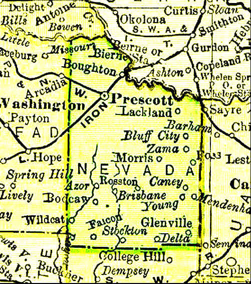
| Nevada County, Arkansas, United States
http://www.histopolis.com/Place/US/AR/Nevada_County
Details for Nevada County
|
|
| Townships of Nevada County
http://www.histopolis.com/Place/US/AR/Nevada_County#AdminDev
13 Townships |
|
| Cemeteries of Nevada County
http://www.histopolis.com/Place/US/AR/Nevada_County#AdminDev
38 Cemeteries, 4 Alternate Names (*) (Cemetery is
assumed unless noted) |
|
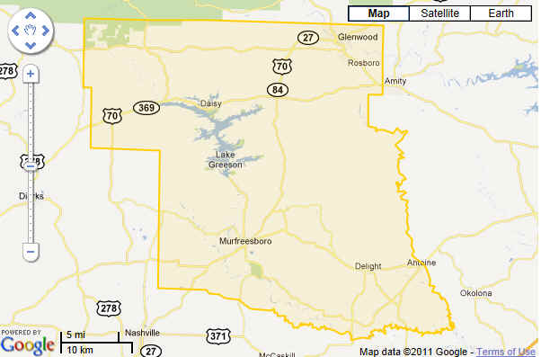
| Pike County, Arkansas, United States
http://www.histopolis.com/Place/US/AR/Pike_County
Details for Pike County
|
|
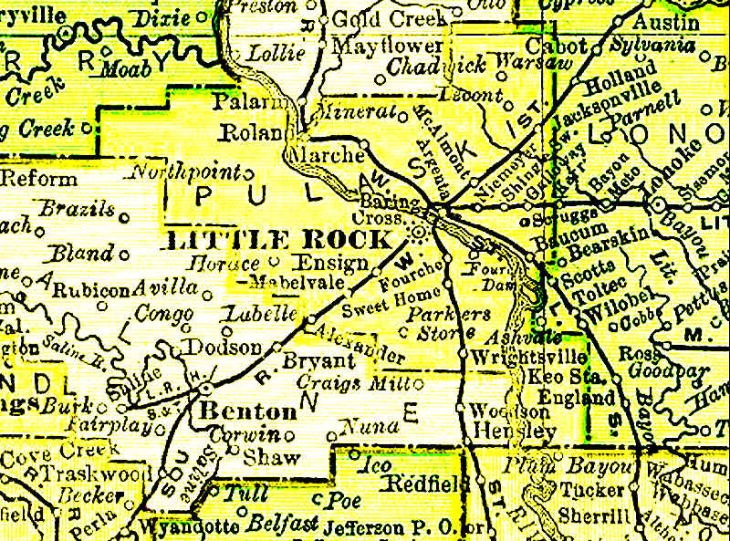
| Pulaski County, Arkansas, United States
http://www.histopolis.com/Place/US/AR/Pulaski_County
Details for Pulaski County
|
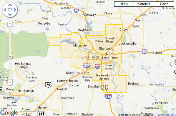
|
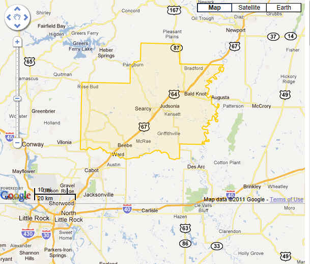
| White County, Arkansas, United States
http://www.histopolis.com/Place/US/AR/White_County
Details for White County
|
|
| Royal Township, White County, Arkansas, United
States
http://www.histopolis.com/Place/US/AR/White_County/Township_of_Royal
Details for Royal Township
|
|
| Cemeteries of White County
http://www.histopolis.com/Place/US/AR/White_County#Cemeteries
54
Cemeteries, 1 Alternate Name (*) (Cemetery is
assumed unless noted) |
|
|
|
| |
|
| |
|
|

|


